Santa María Ipalapa geodata
Santa María Ipalapa (Oaxaca) is a populated place; located in Mexico in America/Mexico_City (GMT-6) time zone. With population of 1,907 people, there are 4560 cities with bigger population in this country. Compared to other cities in Mexico, 93.3% of cities are located further ↑North; 63.2% of cities are located further ←West and 68.7% of cities have higher elevation than Santa María Ipalapa. Note1


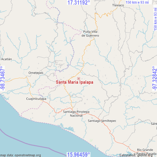
Santa María Ipalapa GPS coordinates[2]
16° 38' 21.984" North, 98° 1' 53.544" West
| Map corner | latitude | longitude |
|---|---|---|
| Upper-left | 17.31192°, | -98.73467° |
| Center: | 16.63944°, | -98.03154° |
| Lower-right: | 15.96459°, | -97.32842° |
| Map W x H: | 149.8×149.8 km | = 93.1×93.1mi |
| max Lat: | 32.7° ⇑93.3% North |
| Santa María Ipalapa: | 16.63944° |
| min Lat: | ⇓6.7% South 14.53588° |
| min Long | Santa María Ip | max Long |
| -117.105° | -98.03154° | -86.73105° |
| W 63.2%⇐ | ⇒36.8% E |
Elevation
Elevation of Santa María Ipalapa is 486 m = 1594 ft, and this is 767.7 m = 2519 ft below average elevation for this country.
| Max E: |
3497 m = 11473 ft | 68.7% |
| Avg. | 1253.7 m = 4113 ft | |
| Santa María Ipalapa | 486 m = 1594 ft | |
Min E: |
-1 m = -3 ft | 31.3% |
See also: Mexico elevation on elevation.city.
Geographical zone
Santa María Ipalapa is located in North Torrid zone (between Equator and Tropic of Cancer). Distance of this Northern Tropic circle is 755.8 km =469.6 mi to North.| Distance of | km | miles | from Santa María Ipalapa |
|---|---|---|---|
| North Pole | 8156.9 | 5068.5 | to North |
| Arctic Circle | 5551 | 3449.2 | to North |
| Tropic Cancer | 755.8 | 469.6 | to North |
| Equator | 1850.1 | 1149.6 | to South |


Nearby cities:
15 places around Santa María Ipalapa: (largest is in red/bold)
• Buenavista
17.2 km =10.7 mi,  268°
268°
• Camotinchan
13.4 km =8.3 mi,  227°
227°
• La Guadalupe
6.3 km =3.9 mi,  309°
309°
• Pie de la Cuesta
10.3 km =6.4 mi,  258°
258°
• San Antonio Ocotlán
14.4 km =8.9 mi, 274°
• San Antonio Tepetlapa
11.2 km =7 mi,  198°
198°
• San Juan Cacahuatepec
13.4 km =8.3 mi, 258°
• San Pedro Amuzgos
6.6 km =4.1 mi,  284°
284°
• San Pedro Atoyac
17.3 km =10.7 mi,  163°
163°
• San Pedro Tulixtlahuaca
11.1 km =6.9 mi,  181°
181°
• San Sebastián Ixcapa
16 km =9.9 mi, 229°
• San Vicente Piñas
16.5 km =10.3 mi,  349°
349°
• Santa María Zacatepec
14.5 km =9 mi,  17°
17°
• Sayultepec
11.5 km =7.1 mi,  245°
245°
• Zocoteaca de León
3.1 km =1.9 mi,  92°
92°
Sources, notices
• [Note1] Compared only with cities in Mexico existing in our database
• [Src1] Map data: © OpenStreetMap contributors (CC-BY-SA)
• [Src2] Other city data from geonames.org with taken over terms of usage.
• [Src3] Geographical zone / Annual Mean Temperature by Robert A. Rohde @ Wikipedia
