Francisco Guerrero geodata
Francisco Guerrero (Chiapas) is a populated place; located in Mexico in America/Mexico_City (GMT-6) time zone. With population of 592 people, there are 14508 cities with bigger population in this country. Compared to other cities in Mexico, 87.4% of cities are located further ↑North; 96.3% of cities are located further ←West and 69.8% of cities have higher elevation than Francisco Guerrero. Note1


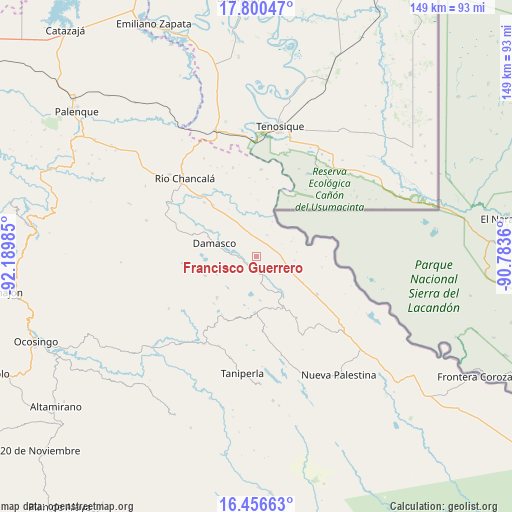
Francisco Guerrero GPS coordinates[2]
17° 7' 47.136" North, 91° 29' 12.192" West
| Map corner | latitude | longitude |
|---|---|---|
| Upper-left | 17.80047°, | -92.18985° |
| Center: | 17.12976°, | -91.48672° |
| Lower-right: | 16.45663°, | -90.7836° |
| Map W x H: | 149.4×149.4 km | = 92.8×92.8mi |
| max Lat: | 32.7° ⇑87.4% North |
| Francisco Guerrero: | 17.12976° |
| min Lat: | ⇓12.6% South 14.53588° |
| min Long | Francisco Guerr | max Long |
| -117.105° | -91.48672° | -86.73105° |
| W 96.3%⇐ | ⇒3.7% E |
Elevation
Elevation of Francisco Guerrero is 427 m = 1401 ft, and this is 826.7 m = 2712 ft below average elevation for this country.
| Max E: |
3497 m = 11473 ft | 69.8% |
| Avg. | 1253.7 m = 4113 ft | |
| Francisco Guerrero | 427 m = 1401 ft | |
Min E: |
-1 m = -3 ft | 30.2% |
See also: Mexico elevation on elevation.city.
Geographical zone
Francisco Guerrero is located in North Torrid zone (between Equator and Tropic of Cancer). Distance of this Northern Tropic circle is 701.3 km =435.8 mi to North.| Distance of | km | miles | from Francisco Guerrero |
|---|---|---|---|
| North Pole | 8102.4 | 5034.6 | to North |
| Arctic Circle | 5496.5 | 3415.4 | to North |
| Tropic Cancer | 701.3 | 435.8 | to North |
| Equator | 1904.7 | 1183.5 | to South |


Nearby cities:
15 places around Francisco Guerrero: (largest is in red/bold)
• Arroyo Granizo
12.2 km =7.6 mi,  147°
147°
• Busiljá
15.4 km =9.6 mi,  120°
120°
• Cristóbal Colón
16.6 km =10.3 mi,  294°
294°
• Damasco
12.6 km =7.8 mi, 286°
• El Edén
17.7 km =11 mi,  334°
334°
• El Jardín
18.4 km =11.4 mi,  194°
194°
• El Sibal
16.7 km =10.4 mi,  181°
181°
• El Tumbo
15.9 km =9.9 mi,  248°
248°
• La Arena
4.1 km =2.5 mi, 246°
• Lacandón
16.7 km =10.4 mi,  223°
223°
• Nueva Samaria
15.2 km =9.4 mi,  299°
299°
• Nuevo Jericó
6 km =3.7 mi,  272°
272°
• Ojo de Agua
7.5 km =4.7 mi, 177°
• Santo Domingo
13.5 km =8.4 mi, 146°
• Ubilio García
5.3 km =3.3 mi,  163°
163°
Sources, notices
• [Note1] Compared only with cities in Mexico existing in our database
• [Src1] Map data: © OpenStreetMap contributors (CC-BY-SA)
• [Src2] Other city data from geonames.org with taken over terms of usage.
• [Src3] Geographical zone / Annual Mean Temperature by Robert A. Rohde @ Wikipedia
