San José Pequetzén geodata
San José Pequetzén (San Luis Potosí) is a populated place; located in Mexico in America/Mexico_City (GMT-6) time zone. With population of 719 people, there are 12132 cities with bigger population in this country. Compared to other cities in Mexico, 82.1% of cities are located further ↓South; 50.9% of cities are located further ←West and 81.2% of cities have higher elevation than San José Pequetzén. Note1


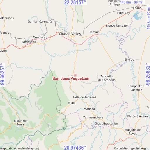
San José Pequetzén GPS coordinates[2]
21° 37' 45.984" North, 98° 57' 33.984" West
| Map corner | latitude | longitude |
|---|---|---|
| Upper-left | 22.28157°, | -99.66257° |
| Center: | 21.62944°, | -98.95944° |
| Lower-right: | 20.97436°, | -98.25632° |
| Map W x H: | 145.3×145.4 km | = 90.3×90.3mi |
| max Lat: | 32.7° ⇑17.9% North |
| San José Pequetzén: | 21.62944° |
| min Lat: | ⇓82.1% South 14.53588° |
| min Long | San José Peque | max Long |
| -117.105° | -98.95944° | -86.73105° |
| W 50.9%⇐ | ⇒49.1% E |
Elevation
Elevation of San José Pequetzén is 79 m = 259 ft, and this is 1174.7 m = 3854 ft below average elevation for this country.
| Max E: |
3497 m = 11473 ft | 81.2% |
| Avg. | 1253.7 m = 4113 ft | |
| San José Pequetzén | 79 m = 259 ft | |
Min E: |
-1 m = -3 ft | 18.8% |
See also: Mexico elevation on elevation.city.
Geographical zone
San José Pequetzén is located in North Torrid zone (between Equator and Tropic of Cancer). Distance of this Northern Tropic circle is 201 km =124.9 mi to North.| Distance of | km | miles | from San José Pequetzén |
|---|---|---|---|
| North Pole | 7602.1 | 4723.7 | to North |
| Arctic Circle | 4996.2 | 3104.5 | to North |
| Tropic Cancer | 201 | 124.9 | to North |
| Equator | 2405 | 1494.4 | to South |


Nearby cities:
15 places around San José Pequetzén: (largest is in red/bold)
• Aquismón
6.3 km =3.9 mi,  262°
262°
• Coromohom (Tocoymohom)
9 km =5.6 mi,  53°
53°
• Ejido San José Xilatzén
6 km =3.7 mi,  33°
33°
• Lanim
5.1 km =3.2 mi,  245°
245°
• Las Armas
7.5 km =4.7 mi,  353°
353°
• San Antonio
5.9 km =3.7 mi,  99°
99°
• Santa Bárbara
8.4 km =5.2 mi,  217°
217°
• Tamcuime
6.2 km =3.9 mi,  239°
239°
• Tampate
6.9 km =4.3 mi,  276°
276°
• Tan Jajnec
6.7 km =4.2 mi,  84°
84°
• Tancanhuitz
3.6 km =2.2 mi,  193°
193°
• Tandzumadz
7.5 km =4.7 mi,  196°
196°
• Tanlajás
8.6 km =5.3 mi,  62°
62°
• Tanute
8.5 km =5.3 mi,  287°
287°
• Tzinejá Uno
7 km =4.3 mi, 186°
Sources, notices
• [Note1] Compared only with cities in Mexico existing in our database
• [Src1] Map data: © OpenStreetMap contributors (CC-BY-SA)
• [Src2] Other city data from geonames.org with taken over terms of usage.
• [Src3] Geographical zone / Annual Mean Temperature by Robert A. Rohde @ Wikipedia
