Tamcuime geodata
Tamcuime (San Luis Potosí) is a populated place; located in Mexico in America/Mexico_City (GMT-6) time zone. With population of 2,080 people, there are 4199 cities with bigger population in this country. Compared to other cities in Mexico, 81.9% of cities are located further ↓South; 50% of cities are located further ←West and 79.9% of cities have higher elevation than Tamcuime. Note1


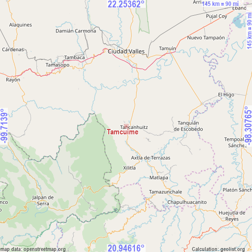
Tamcuime GPS coordinates[2]
21° 36' 4.932" North, 99° 0' 38.772" West
| Map corner | latitude | longitude |
|---|---|---|
| Upper-left | 22.25362°, | -99.7139° |
| Center: | 21.60137°, | -99.01077° |
| Lower-right: | 20.94616°, | -98.30765° |
| Map W x H: | 145.4×145.4 km | = 90.3×90.3mi |
| max Lat: | 32.7° ⇑18.1% North |
| Tamcuime: | 21.60137° |
| min Lat: | ⇓81.9% South 14.53588° |
| min Long | Tamcuime | max Long |
| -117.105° | -99.01077° | -86.73105° |
| W 50%⇐ | ⇒50% E |
Elevation
Elevation of Tamcuime is 96 m = 315 ft, and this is 1157.7 m = 3798 ft below average elevation for this country.
| Max E: |
3497 m = 11473 ft | 79.9% |
| Avg. | 1253.7 m = 4113 ft | |
| Tamcuime | 96 m = 315 ft | |
Min E: |
-1 m = -3 ft | 20.1% |
See also: Mexico elevation on elevation.city.
Geographical zone
Tamcuime is located in North Torrid zone (between Equator and Tropic of Cancer). Distance of this Northern Tropic circle is 204.1 km =126.8 mi to North.| Distance of | km | miles | from Tamcuime |
|---|---|---|---|
| North Pole | 7605.2 | 4725.7 | to North |
| Arctic Circle | 4999.3 | 3106.4 | to North |
| Tropic Cancer | 204.1 | 126.8 | to North |
| Equator | 2401.8 | 1492.4 | to South |


Nearby cities:
15 places around Tamcuime: (largest is in red/bold)
• Alitzé
8 km =5 mi,  233°
233°
• Aquismón
2.4 km =1.5 mi,  337°
337°
• Cruz Blanca
6.8 km =4.2 mi,  173°
173°
• Huehuetlán
7.6 km =4.7 mi,  143°
143°
• Jol Mom
7.8 km =4.8 mi,  212°
212°
• Lanim
1.2 km =0.7 mi,  32°
32°
• Mantezulel
5.5 km =3.4 mi,  301°
301°
• San José Pequetzén
6.2 km =3.9 mi,  59°
59°
• Santa Bárbara
3.6 km =2.2 mi,  176°
176°
• Tampate
4.2 km =2.6 mi, 338°
• Tamápatz
7.9 km =4.9 mi,  240°
240°
• Tancanhuitz
4.5 km =2.8 mi,  94°
94°
• Tandzumadz
5.1 km =3.2 mi, 141°
• Tanute
6.3 km =3.9 mi,  333°
333°
• Tzinejá Uno
6 km =3.7 mi,  130°
130°
Sources, notices
• [Note1] Compared only with cities in Mexico existing in our database
• [Src1] Map data: © OpenStreetMap contributors (CC-BY-SA)
• [Src2] Other city data from geonames.org with taken over terms of usage.
• [Src3] Geographical zone / Annual Mean Temperature by Robert A. Rohde @ Wikipedia
