Tlixco geodata
Tlixco (Puebla) is a populated place; located in Mexico in America/Mexico_City (GMT-6) time zone. With population of 1,329 people, there are 6536 cities with bigger population in this country. Compared to other cities in Mexico, 75.3% of cities are located further ↑North; 74.8% of cities are located further ←West and 83% of cities have lower elevation than Tlixco. Note1


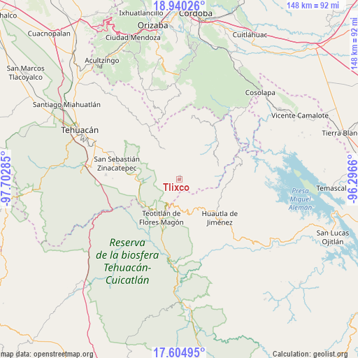
Tlixco GPS coordinates[2]
18° 16' 26.004" North, 96° 59' 58.992" West
| Map corner | latitude | longitude |
|---|---|---|
| Upper-left | 18.94026°, | -97.70285° |
| Center: | 18.27389°, | -96.99972° |
| Lower-right: | 17.60495°, | -96.2966° |
| Map W x H: | 148.5×148.5 km | = 92.3×92.3mi |
| max Lat: | 32.7° ⇑75.3% North |
| Tlixco: | 18.27389° |
| min Lat: | ⇓24.7% South 14.53588° |
| min Long | Tlixco | max Long |
| -117.105° | -96.99972° | -86.73105° |
| W 74.8%⇐ | ⇒25.2% E |
Elevation
Elevation of Tlixco is 2214 m = 7264 ft, and this is 960.3 m = 3151 ft above average elevation for this country.
| Max E: |
3497 m = 11473 ft | 17% |
| Tlixco | 2214 m 7264 ft | |
| Avg. | 1253.7 m = 4113 ft | |
Min E: |
-1 m = -3 ft | 83% |
See also: Mexico elevation on elevation.city.
Geographical zone
Tlixco is located in North Torrid zone (between Equator and Tropic of Cancer). Distance of this Northern Tropic circle is 574.1 km =356.7 mi to North.| Distance of | km | miles | from Tlixco |
|---|---|---|---|
| North Pole | 7975.2 | 4955.6 | to North |
| Arctic Circle | 5369.3 | 3336.3 | to North |
| Tropic Cancer | 574.1 | 356.7 | to North |
| Equator | 2031.9 | 1262.6 | to South |


Nearby cities:
15 places around Tlixco: (largest is in red/bold)
• Chichiltepec
10.3 km =6.4 mi,  248°
248°
• Coyomeapan
1.1 km =0.7 mi,  36°
36°
• Huehuetlán Segunda Sección
10.6 km =6.6 mi,  146°
146°
• Ocotlamanic
11.6 km =7.2 mi,  298°
298°
• San Francisco Huehuetlán
10.1 km =6.3 mi, 147°
• San Juan Cuautla
5.6 km =3.5 mi,  126°
126°
• Santiago Texcalcingo
8 km =5 mi,  155°
155°
• Segunda Sección
1.3 km =0.8 mi,  330°
330°
• Tecoltepec
10.1 km =6.3 mi, 304°
• Tepantitlán
7.6 km =4.7 mi,  167°
167°
• Tepoxtla
3.6 km =2.2 mi, 168°
• Villa Nueva
10.8 km =6.7 mi, 169°
• Xitlama
3.8 km =2.4 mi, 330°
• Zoquitlanzacualco
7 km =4.3 mi, 329°
• Zoquitlán
7.1 km =4.4 mi,  344°
344°
Sources, notices
• [Note1] Compared only with cities in Mexico existing in our database
• [Src1] Map data: © OpenStreetMap contributors (CC-BY-SA)
• [Src2] Other city data from geonames.org with taken over terms of usage.
• [Src3] Geographical zone / Annual Mean Temperature by Robert A. Rohde @ Wikipedia
