Chichiltepec geodata
Chichiltepec (Puebla) is a populated place; located in Mexico in America/Mexico_City (GMT-6) time zone. With population of 651 people, there are 13306 cities with bigger population in this country. Compared to other cities in Mexico, 75.7% of cities are located further ↑North; 73.7% of cities are located further ←West and 79.6% of cities have lower elevation than Chichiltepec. Note1


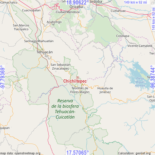
Chichiltepec GPS coordinates[2]
18° 14' 22.992" North, 97° 5' 26.016" West
| Map corner | latitude | longitude |
|---|---|---|
| Upper-left | 18.90622°, | -97.79369° |
| Center: | 18.23972°, | -97.09056° |
| Lower-right: | 17.57065°, | -96.38744° |
| Map W x H: | 148.5×148.5 km | = 92.3×92.3mi |
| max Lat: | 32.7° ⇑75.7% North |
| Chichiltepec: | 18.23972° |
| min Lat: | ⇓24.3% South 14.53588° |
| min Long | Chichiltepec | max Long |
| -117.105° | -97.09056° | -86.73105° |
| W 73.7%⇐ | ⇒26.3% E |
Elevation
Elevation of Chichiltepec is 2132 m = 6995 ft, and this is 878.3 m = 2882 ft above average elevation for this country.
| Max E: |
3497 m = 11473 ft | 20.4% |
| Chichiltepec | 2132 m 6995 ft | |
| Avg. | 1253.7 m = 4113 ft | |
Min E: |
-1 m = -3 ft | 79.6% |
See also: Mexico elevation on elevation.city.
Geographical zone
Chichiltepec is located in North Torrid zone (between Equator and Tropic of Cancer). Distance of this Northern Tropic circle is 577.9 km =359.1 mi to North.| Distance of | km | miles | from Chichiltepec |
|---|---|---|---|
| North Pole | 7979 | 4957.9 | to North |
| Arctic Circle | 5373.1 | 3338.7 | to North |
| Tropic Cancer | 577.9 | 359.1 | to North |
| Equator | 2028.1 | 1260.2 | to South |


Nearby cities:
15 places around Chichiltepec: (largest is in red/bold)
• Axuxco
12.4 km =7.7 mi,  265°
265°
• Calipan
9.9 km =6.2 mi,  308°
308°
• Coxcatlán
7 km =4.3 mi,  295°
295°
• Coyomeapan
11.3 km =7 mi,  65°
65°
• Nanahuatípam
12.3 km =7.6 mi,  197°
197°
• Ocotlamanic
9.4 km =5.8 mi,  356°
356°
• San José Tilapa
8.5 km =5.3 mi,  187°
187°
• Segunda Sección
10.2 km =6.3 mi,  61°
61°
• Tecoltepec
9.6 km =6 mi,  7°
7°
• Teotitlán
12.2 km =7.6 mi,  170°
170°
• Tepantitlán
11.8 km =7.3 mi,  108°
108°
• Tepoxtla
10.3 km =6.4 mi,  88°
88°
• Tlixco
10.3 km =6.4 mi, 68°
• Xitlama
10.5 km =6.5 mi,  47°
47°
• Zoquitlanzacualco
11.5 km =7.1 mi,  31°
31°
Sources, notices
• [Note1] Compared only with cities in Mexico existing in our database
• [Src1] Map data: © OpenStreetMap contributors (CC-BY-SA)
• [Src2] Other city data from geonames.org with taken over terms of usage.
• [Src3] Geographical zone / Annual Mean Temperature by Robert A. Rohde @ Wikipedia
