Tepoxtla geodata
Tepoxtla (Puebla) is a populated place; located in Mexico in America/Mexico_City (GMT-6) time zone. With population of 548 people, there are 15532 cities with bigger population in this country. Compared to other cities in Mexico, 75.6% of cities are located further ↑North; 74.9% of cities are located further ←West and 76.6% of cities have lower elevation than Tepoxtla. Note1


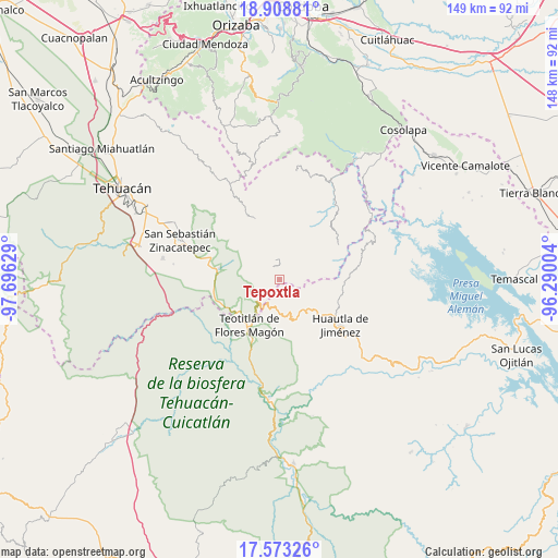
Tepoxtla GPS coordinates[2]
18° 14' 32.352" North, 96° 59' 35.376" West
| Map corner | latitude | longitude |
|---|---|---|
| Upper-left | 18.90881°, | -97.69629° |
| Center: | 18.24232°, | -96.99316° |
| Lower-right: | 17.57326°, | -96.29004° |
| Map W x H: | 148.5×148.5 km | = 92.3×92.3mi |
| max Lat: | 32.7° ⇑75.6% North |
| Tepoxtla: | 18.24232° |
| min Lat: | ⇓24.4% South 14.53588° |
| min Long | Tepoxtla | max Long |
| -117.105° | -96.99316° | -86.73105° |
| W 74.9%⇐ | ⇒25.1% E |
Elevation
Elevation of Tepoxtla is 2060 m = 6759 ft, and this is 806.3 m = 2645 ft above average elevation for this country.
| Max E: |
3497 m = 11473 ft | 23.4% |
| Tepoxtla | 2060 m 6759 ft | |
| Avg. | 1253.7 m = 4113 ft | |
Min E: |
-1 m = -3 ft | 76.6% |
See also: Mexico elevation on elevation.city.
Geographical zone
Tepoxtla is located in North Torrid zone (between Equator and Tropic of Cancer). Distance of this Northern Tropic circle is 577.6 km =358.9 mi to North.| Distance of | km | miles | from Tepoxtla |
|---|---|---|---|
| North Pole | 7978.7 | 4957.7 | to North |
| Arctic Circle | 5372.8 | 3338.5 | to North |
| Tropic Cancer | 577.6 | 358.9 | to North |
| Equator | 2028.4 | 1260.4 | to South |


Nearby cities:
15 places around Tepoxtla: (largest is in red/bold)
• Chichiltepec
10.3 km =6.4 mi,  268°
268°
• Coyomeapan
4.4 km =2.7 mi,  359°
359°
• Huehuetlán Segunda Sección
7.5 km =4.7 mi,  135°
135°
• San Francisco Huehuetlán
6.9 km =4.3 mi, 136°
• San Juan Cuautla
3.9 km =2.4 mi,  86°
86°
• San Lorenzo Cuaunecuiltitla
9.3 km =5.8 mi,  115°
115°
• Santa María Teopoxco
9.3 km =5.8 mi,  154°
154°
• Santiago Texcalcingo
4.6 km =2.9 mi, 145°
• Segunda Sección
4.8 km =3 mi,  343°
343°
• Tecuanapam
9.5 km =5.9 mi,  158°
158°
• Tepantitlán
4.1 km =2.5 mi,  166°
166°
• Tlixco
3.6 km =2.2 mi,  348°
348°
• Villa Nueva
7.2 km =4.5 mi, 169°
• Xitlama
7.3 km =4.5 mi, 339°
• Zoquitlanzacualco
10.4 km =6.5 mi, 336°
Sources, notices
• [Note1] Compared only with cities in Mexico existing in our database
• [Src1] Map data: © OpenStreetMap contributors (CC-BY-SA)
• [Src2] Other city data from geonames.org with taken over terms of usage.
• [Src3] Geographical zone / Annual Mean Temperature by Robert A. Rohde @ Wikipedia
