Mitzitón geodata
Mitzitón (Chiapas) is a populated place; located in Mexico in America/Mexico_City (GMT-6) time zone. With population of 1,293 people, there are 6703 cities with bigger population in this country. Compared to other cities in Mexico, 93.3% of cities are located further ↑North; 91.5% of cities are located further ←West and 89.3% of cities have lower elevation than Mitzitón. Note1


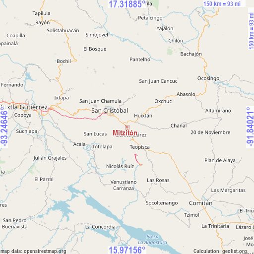
Mitzitón GPS coordinates[2]
16° 38' 47.004" North, 92° 32' 35.988" West
| Map corner | latitude | longitude |
|---|---|---|
| Upper-left | 17.31885°, | -93.24646° |
| Center: | 16.64639°, | -92.54333° |
| Lower-right: | 15.97156°, | -91.84021° |
| Map W x H: | 149.8×149.8 km | = 93.1×93.1mi |
| max Lat: | 32.7° ⇑93.3% North |
| Mitzitón: | 16.64639° |
| min Lat: | ⇓6.7% South 14.53588° |
| min Long | Mitzitón | max Long |
| -117.105° | -92.54333° | -86.73105° |
| W 91.5%⇐ | ⇒8.5% E |
Elevation
Elevation of Mitzitón is 2381 m = 7812 ft, and this is 1127.3 m = 3698 ft above average elevation for this country.
| Max E: |
3497 m = 11473 ft | 10.7% |
| Mitzitón | 2381 m 7812 ft | |
| Avg. | 1253.7 m = 4113 ft | |
Min E: |
-1 m = -3 ft | 89.3% |
See also: Mexico elevation on elevation.city.
Geographical zone
Mitzitón is located in North Torrid zone (between Equator and Tropic of Cancer). Distance of this Northern Tropic circle is 755 km =469.1 mi to North.| Distance of | km | miles | from Mitzitón |
|---|---|---|---|
| North Pole | 8156.2 | 5068 | to North |
| Arctic Circle | 5550.3 | 3448.8 | to North |
| Tropic Cancer | 755 | 469.1 | to North |
| Equator | 1850.9 | 1150.1 | to South |


Nearby cities:
15 places around Mitzitón: (largest is in red/bold)
• Betania
5 km =3.1 mi,  152°
152°
• Campo Santiago
9.2 km =5.7 mi,  168°
168°
• Corazón de María
6 km =3.7 mi,  9°
9°
• Dolores
5.6 km =3.5 mi, 147°
• El Aguaje (La Albarada)
6.8 km =4.2 mi,  312°
312°
• El Escalón
7.2 km =4.5 mi,  21°
21°
• Galilea
5.4 km =3.4 mi,  138°
138°
• Jardín del Nuevo Edén
6.8 km =4.2 mi, 152°
• La Sierra
7.4 km =4.6 mi,  0°
0°
• La Soledad
4.2 km =2.6 mi,  37°
37°
• Lázaro Cárdenas (Chilil)
6.6 km =4.1 mi,  60°
60°
• Nuevo Zinacantán
5.3 km =3.3 mi, 152°
• San Pedro la Tejería
9.8 km =6.1 mi, 21°
• Tzajalha
9.4 km =5.8 mi,  121°
121°
• Vistahermosa
8.2 km =5.1 mi, 152°
Sources, notices
• [Note1] Compared only with cities in Mexico existing in our database
• [Src1] Map data: © OpenStreetMap contributors (CC-BY-SA)
• [Src2] Other city data from geonames.org with taken over terms of usage.
• [Src3] Geographical zone / Annual Mean Temperature by Robert A. Rohde @ Wikipedia
