San Roque geodata
San Roque (State of Mexico) is a populated place; located in Mexico in America/Mexico_City (GMT-6) time zone. With population of 1,283 people, there are 6755 cities with bigger population in this country. Compared to other cities in Mexico, 54.5% of cities are located further ↑North; 63.5% of cities are located further →East and 95.7% of cities have lower elevation than San Roque. Note1


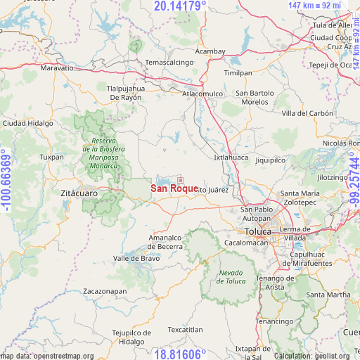
San Roque GPS coordinates[2]
19° 28' 49.008" North, 99° 57' 38.016" West
| Map corner | latitude | longitude |
|---|---|---|
| Upper-left | 20.14179°, | -100.66369° |
| Center: | 19.48028°, | -99.96056° |
| Lower-right: | 18.81606°, | -99.25744° |
| Map W x H: | 147.4×147.4 km | = 91.6×91.6mi |
| max Lat: | 32.7° ⇑54.5% North |
| San Roque: | 19.48028° |
| min Lat: | ⇓45.5% South 14.53588° |
| min Long | San Roque | max Long |
| -117.105° | -99.96056° | -86.73105° |
| W 36.5%⇐ | ⇒63.5% E |
Elevation
Elevation of San Roque is 2616 m = 8583 ft, and this is 1362.3 m = 4469 ft above average elevation for this country.
| Max E: |
3497 m = 11473 ft | 4.3% |
| San Roque | 2616 m 8583 ft | |
| Avg. | 1253.7 m = 4113 ft | |
Min E: |
-1 m = -3 ft | 95.7% |
See also: Mexico elevation on elevation.city.
Geographical zone
San Roque is located in North Torrid zone (between Equator and Tropic of Cancer). Distance of this Northern Tropic circle is 439.9 km =273.3 mi to North.| Distance of | km | miles | from San Roque |
|---|---|---|---|
| North Pole | 7841.1 | 4872.2 | to North |
| Arctic Circle | 5235.2 | 3253 | to North |
| Tropic Cancer | 439.9 | 273.3 | to North |
| Equator | 2166 | 1345.9 | to South |


Nearby cities:
15 places around San Roque: (largest is in red/bold)
• Barrio de San Isidro
4.6 km =2.9 mi,  2°
2°
• Barrio de San Miguel
3.6 km =2.2 mi,  9°
9°
• Barrio el Centenario
5.6 km =3.5 mi,  319°
319°
• Barrio el Ocote
2.3 km =1.4 mi,  127°
127°
• Casa Nueva (Casa Nueva Yebuciví)
4.8 km =3 mi,  76°
76°
• Cuadrilla Vieja
4.5 km =2.8 mi, 321°
• La Alameda
3.8 km =2.4 mi,  331°
331°
• La Campanilla
3.8 km =2.4 mi,  30°
30°
• Las Peñas
5.3 km =3.3 mi,  230°
230°
• Loma de Guadalupe
5.3 km =3.3 mi,  307°
307°
• Piedras Blancas (Piedras Blancas Centro)
5.8 km =3.6 mi, 27°
• Río Frío (Río Frío Yebuciví)
4.8 km =3 mi,  44°
44°
• San Diego del Cerrito
5.7 km =3.5 mi,  302°
302°
• San Marcos de la Loma
2.3 km =1.4 mi, 0°
• Venta de Ocotillos
1 km =0.6 mi,  169°
169°
Sources, notices
• [Note1] Compared only with cities in Mexico existing in our database
• [Src1] Map data: © OpenStreetMap contributors (CC-BY-SA)
• [Src2] Other city data from geonames.org with taken over terms of usage.
• [Src3] Geographical zone / Annual Mean Temperature by Robert A. Rohde @ Wikipedia
