Xalticpac geodata
Xalticpac (Puebla) is a populated place; located in Mexico in America/Mexico_City (GMT-6) time zone. With population of 1,214 people, there are 7165 cities with bigger population in this country. Compared to other cities in Mexico, 53.8% of cities are located further ↓South; 68.5% of cities are located further ←West and 72.3% of cities have lower elevation than Xalticpac. Note1


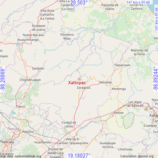
Xalticpac GPS coordinates[2]
19° 50' 34.836" North, 97° 35' 44.016" West
| Map corner | latitude | longitude |
|---|---|---|
| Upper-left | 20.503°, | -98.29869° |
| Center: | 19.84301°, | -97.59556° |
| Lower-right: | 19.18027°, | -96.89244° |
| Map W x H: | 147.1×147.1 km | = 91.4×91.4mi |
| max Lat: | 32.7° ⇑46.2% North |
| Xalticpac: | 19.84301° |
| min Lat: | ⇓53.8% South 14.53588° |
| min Long | Xalticpac | max Long |
| -117.105° | -97.59556° | -86.73105° |
| W 68.5%⇐ | ⇒31.5% E |
Elevation
Elevation of Xalticpac is 1973 m = 6473 ft, and this is 719.3 m = 2360 ft above average elevation for this country.
| Max E: |
3497 m = 11473 ft | 27.7% |
| Xalticpac | 1973 m 6473 ft | |
| Avg. | 1253.7 m = 4113 ft | |
Min E: |
-1 m = -3 ft | 72.3% |
See also: Mexico elevation on elevation.city.
Geographical zone
Xalticpac is located in North Torrid zone (between Equator and Tropic of Cancer). Distance of this Northern Tropic circle is 399.6 km =248.3 mi to North.| Distance of | km | miles | from Xalticpac |
|---|---|---|---|
| North Pole | 7800.7 | 4847.1 | to North |
| Arctic Circle | 5194.8 | 3227.9 | to North |
| Tropic Cancer | 399.6 | 248.3 | to North |
| Equator | 2206.3 | 1370.9 | to South |


Nearby cities:
15 places around Xalticpac: (largest is in red/bold)
• Atalpan
3.7 km =2.3 mi,  88°
88°
• Comaltepec
1.8 km =1.1 mi,  347°
347°
• Cuacuilco
5.5 km =3.4 mi,  80°
80°
• El Molino
3.7 km =2.3 mi,  154°
154°
• Francisco I. Madero
5.3 km =3.3 mi,  178°
178°
• Héroes del Cinco de Mayo
2.4 km =1.5 mi, 183°
• Jilotepec
5.9 km =3.7 mi,  216°
216°
• Las Lomas
2.8 km =1.7 mi, 219°
• Los Cristales (Talican)
3.3 km =2.1 mi,  2°
2°
• Nexticapan
4.7 km =2.9 mi,  112°
112°
• Plan de Guadalupe
6.2 km =3.9 mi,  131°
131°
• San Francisco Zacapexpan
4.1 km =2.5 mi,  359°
359°
• Santa Cruz Xaltetela
3.8 km =2.4 mi,  23°
23°
• Tatoxcac
3.8 km =2.4 mi,  38°
38°
• Zacapoaxtla
3.4 km =2.1 mi,  11°
11°
Sources, notices
• [Note1] Compared only with cities in Mexico existing in our database
• [Src1] Map data: © OpenStreetMap contributors (CC-BY-SA)
• [Src2] Other city data from geonames.org with taken over terms of usage.
• [Src3] Geographical zone / Annual Mean Temperature by Robert A. Rohde @ Wikipedia
