San Antonio Bulujib geodata
San Antonio Bulujib (Chiapas) is a populated place; located in Mexico in America/Mexico_City (GMT-6) time zone. With population of 1,206 people, there are 7208 cities with bigger population in this country. Compared to other cities in Mexico, 88.9% of cities are located further ↑North; 93.4% of cities are located further ←West and 59.1% of cities have higher elevation than San Antonio Bulujib. Note1


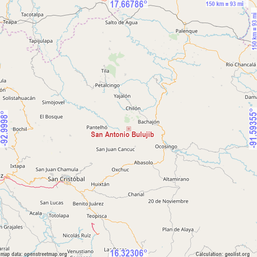
San Antonio Bulujib GPS coordinates[2]
16° 59' 48.012" North, 92° 17' 48.012" West
| Map corner | latitude | longitude |
|---|---|---|
| Upper-left | 17.66786°, | -92.9998° |
| Center: | 16.99667°, | -92.29667° |
| Lower-right: | 16.32306°, | -91.59355° |
| Map W x H: | 149.5×149.5 km | = 92.9×92.9mi |
| max Lat: | 32.7° ⇑88.9% North |
| San Antonio Bulujib: | 16.99667° |
| min Lat: | ⇓11.1% South 14.53588° |
| min Long | San Antonio Bul | max Long |
| -117.105° | -92.29667° | -86.73105° |
| W 93.4%⇐ | ⇒6.6% E |
Elevation
Elevation of San Antonio Bulujib is 1047 m = 3435 ft, and this is 206.7 m = 678 ft below average elevation for this country.
| Max E: |
3497 m = 11473 ft | 59.1% |
| Avg. | 1253.7 m = 4113 ft | |
| San Antonio Bulujib | 1047 m = 3435 ft | |
Min E: |
-1 m = -3 ft | 40.9% |
See also: Mexico elevation on elevation.city.
Geographical zone
San Antonio Bulujib is located in North Torrid zone (between Equator and Tropic of Cancer). Distance of this Northern Tropic circle is 716.1 km =445 mi to North.| Distance of | km | miles | from San Antonio Bulujib |
|---|---|---|---|
| North Pole | 8117.2 | 5043.8 | to North |
| Arctic Circle | 5511.3 | 3424.6 | to North |
| Tropic Cancer | 716.1 | 445 | to North |
| Equator | 1889.9 | 1174.3 | to South |


Nearby cities:
15 places around San Antonio Bulujib: (largest is in red/bold)
• Baquelchán
5.8 km =3.6 mi,  259°
259°
• Chacté
8.7 km =5.4 mi,  221°
221°
• Golonchán Viejo
10.2 km =6.3 mi,  292°
292°
• Guaquitepec
2.1 km =1.3 mi,  153°
153°
• Juan Sabines Verapaz
9 km =5.6 mi,  349°
349°
• La Frontera Uno
7.3 km =4.5 mi,  170°
170°
• La Palma Uno
8.2 km =5.1 mi,  253°
253°
• Mequeja
7.8 km =4.8 mi,  123°
123°
• Oniltic
10.1 km =6.3 mi, 252°
• San Marcos
10 km =6.2 mi, 115°
• Santa Cruz la Reforma
6.3 km =3.9 mi,  359°
359°
• Sitalá
3.2 km =2 mi,  340°
340°
• Tenango
10.9 km =6.8 mi,  159°
159°
• Tzunjok
11 km =6.8 mi,  240°
240°
• Yocwitz
9.5 km =5.9 mi, 262°
Sources, notices
• [Note1] Compared only with cities in Mexico existing in our database
• [Src1] Map data: © OpenStreetMap contributors (CC-BY-SA)
• [Src2] Other city data from geonames.org with taken over terms of usage.
• [Src3] Geographical zone / Annual Mean Temperature by Robert A. Rohde @ Wikipedia
