Mequeja geodata
Mequeja (Chiapas) is a populated place; located in Mexico in America/Mexico_City (GMT-6) time zone. With population of 913 people, there are 9556 cities with bigger population in this country. Compared to other cities in Mexico, 89.5% of cities are located further ↑North; 93.9% of cities are located further ←West and 58.3% of cities have higher elevation than Mequeja. Note1


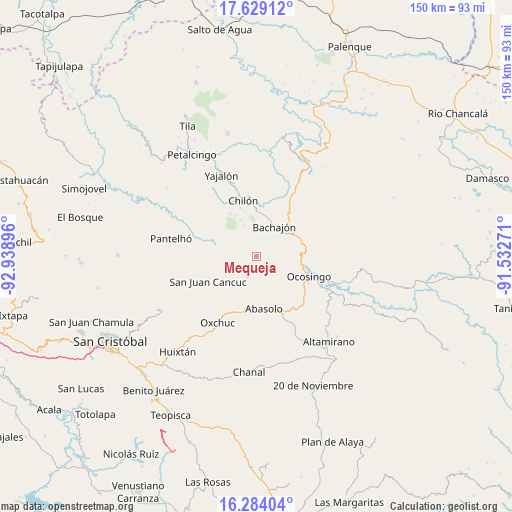
Mequeja GPS coordinates[2]
16° 57' 28.008" North, 92° 14' 8.988" West
| Map corner | latitude | longitude |
|---|---|---|
| Upper-left | 17.62912°, | -92.93896° |
| Center: | 16.95778°, | -92.23583° |
| Lower-right: | 16.28404°, | -91.53271° |
| Map W x H: | 149.6×149.6 km | = 93×93mi |
| max Lat: | 32.7° ⇑89.5% North |
| Mequeja: | 16.95778° |
| min Lat: | ⇓10.5% South 14.53588° |
| min Long | Mequeja | max Long |
| -117.105° | -92.23583° | -86.73105° |
| W 93.9%⇐ | ⇒6.1% E |
Elevation
Elevation of Mequeja is 1094 m = 3589 ft, and this is 159.7 m = 524 ft below average elevation for this country.
| Max E: |
3497 m = 11473 ft | 58.3% |
| Avg. | 1253.7 m = 4113 ft | |
| Mequeja | 1094 m = 3589 ft | |
Min E: |
-1 m = -3 ft | 41.7% |
See also: Mexico elevation on elevation.city.
Geographical zone
Mequeja is located in North Torrid zone (between Equator and Tropic of Cancer). Distance of this Northern Tropic circle is 720.4 km =447.6 mi to North.| Distance of | km | miles | from Mequeja |
|---|---|---|---|
| North Pole | 8121.5 | 5046.5 | to North |
| Arctic Circle | 5515.6 | 3427.2 | to North |
| Tropic Cancer | 720.4 | 447.6 | to North |
| Equator | 1885.5 | 1171.6 | to South |


Nearby cities:
15 places around Mequeja: (largest is in red/bold)
• Altamirano
12.3 km =7.6 mi,  132°
132°
• Bachajón
10.3 km =6.4 mi,  28°
28°
• Baquelchán
12.6 km =7.8 mi,  284°
284°
• Chacté
12.4 km =7.7 mi,  259°
259°
• El Tzay
13.3 km =8.3 mi,  217°
217°
• Guaquitepec
6.1 km =3.8 mi,  294°
294°
• Joybé
11 km =6.8 mi,  52°
52°
• La Frontera Uno
6 km =3.7 mi,  240°
240°
• La Virginia
11.1 km =6.9 mi,  143°
143°
• San Antonio Bulujib
7.8 km =4.8 mi,  303°
303°
• San Marcos
2.6 km =1.6 mi,  89°
89°
• Santa Cruz la Reforma
12.5 km =7.8 mi,  328°
328°
• Sibacá
10.6 km =6.6 mi,  106°
106°
• Sitalá
10.6 km =6.6 mi,  314°
314°
• Tenango
6.5 km =4 mi,  204°
204°
Sources, notices
• [Note1] Compared only with cities in Mexico existing in our database
• [Src1] Map data: © OpenStreetMap contributors (CC-BY-SA)
• [Src2] Other city data from geonames.org with taken over terms of usage.
• [Src3] Geographical zone / Annual Mean Temperature by Robert A. Rohde @ Wikipedia
