Santa Cruz la Reforma geodata
Santa Cruz la Reforma (Chiapas) is a populated place; located in Mexico in America/Mexico_City (GMT-6) time zone. With population of 921 people, there are 9483 cities with bigger population in this country. Compared to other cities in Mexico, 88.2% of cities are located further ↑North; 93.4% of cities are located further ←West and 53.2% of cities have higher elevation than Santa Cruz la Reforma. Note1


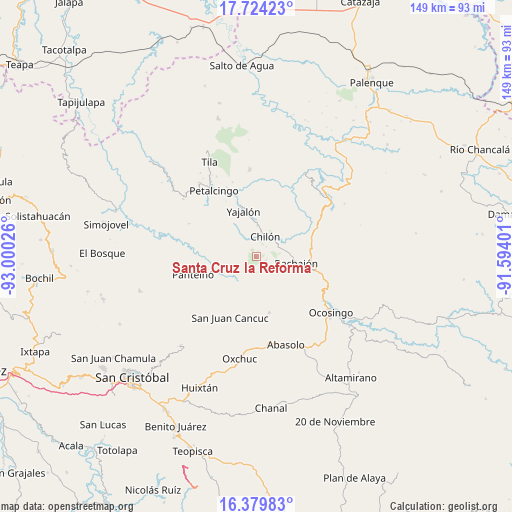
Santa Cruz la Reforma GPS coordinates[2]
17° 3' 11.664" North, 92° 17' 49.668" West
| Map corner | latitude | longitude |
|---|---|---|
| Upper-left | 17.72423°, | -93.00026° |
| Center: | 17.05324°, | -92.29713° |
| Lower-right: | 16.37983°, | -91.59401° |
| Map W x H: | 149.5×149.5 km | = 92.9×92.9mi |
| max Lat: | 32.7° ⇑88.2% North |
| Santa Cruz la Reforma: | 17.05324° |
| min Lat: | ⇓11.8% South 14.53588° |
| min Long | Santa Cruz la R | max Long |
| -117.105° | -92.29713° | -86.73105° |
| W 93.4%⇐ | ⇒6.6% E |
Elevation
Elevation of Santa Cruz la Reforma is 1283 m = 4209 ft, and this is 29.3 m = 96 ft above average elevation for this country.
| Max E: |
3497 m = 11473 ft | 53.2% |
| Santa Cruz la Reforma | 1283 m 4209 ft | |
| Avg. | 1253.7 m = 4113 ft | |
Min E: |
-1 m = -3 ft | 46.8% |
See also: Mexico elevation on elevation.city.
Geographical zone
Santa Cruz la Reforma is located in North Torrid zone (between Equator and Tropic of Cancer). Distance of this Northern Tropic circle is 709.8 km =441 mi to North.| Distance of | km | miles | from Santa Cruz la Reforma |
|---|---|---|---|
| North Pole | 8110.9 | 5039.9 | to North |
| Arctic Circle | 5505 | 3420.6 | to North |
| Tropic Cancer | 709.8 | 441 | to North |
| Equator | 1896.1 | 1178.2 | to South |


Nearby cities:
15 places around Santa Cruz la Reforma: (largest is in red/bold)
• Aurora Grande
10.8 km =6.7 mi,  325°
325°
• Bachajón
11.5 km =7.1 mi,  97°
97°
• Baquelchán
9.3 km =5.8 mi,  217°
217°
• Chilón
6.4 km =4 mi,  23°
23°
• Golonchán Viejo
9.6 km =6 mi,  255°
255°
• Guaquitepec
8.2 km =5.1 mi,  173°
173°
• Insurgente Picoté
9.1 km =5.7 mi,  274°
274°
• Juan Sabines Verapaz
3 km =1.9 mi, 329°
• La Palma Uno
11.7 km =7.3 mi, 222°
• Mequeja
12.5 km =7.8 mi,  148°
148°
• San Antonio Bulujib
6.3 km =3.9 mi,  179°
179°
• Sitalá
3.4 km =2.1 mi,  197°
197°
• Tacuba Nueva
8.8 km =5.5 mi,  297°
297°
• Tzasibiltic
10.5 km =6.5 mi,  4°
4°
• Yocwitz
12.1 km =7.5 mi,  231°
231°
Sources, notices
• [Note1] Compared only with cities in Mexico existing in our database
• [Src1] Map data: © OpenStreetMap contributors (CC-BY-SA)
• [Src2] Other city data from geonames.org with taken over terms of usage.
• [Src3] Geographical zone / Annual Mean Temperature by Robert A. Rohde @ Wikipedia
