Pochálcatl geodata
Pochálcatl (Puebla) is a populated place; located in Mexico in America/Mexico_City (GMT-6) time zone. With population of 1,160 people, there are 7479 cities with bigger population in this country. Compared to other cities in Mexico, 57% of cities are located further ↓South; 65.4% of cities are located further ←West and 50.8% of cities have higher elevation than Pochálcatl. Note1


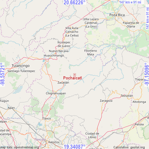
Pochálcatl GPS coordinates[2]
20° 0' 10.62" North, 97° 51' 14.688" West
| Map corner | latitude | longitude |
|---|---|---|
| Upper-left | 20.66226°, | -98.55721° |
| Center: | 20.00295°, | -97.85408° |
| Lower-right: | 19.34087°, | -97.15096° |
| Map W x H: | 146.9×146.9 km | = 91.3×91.3mi |
| max Lat: | 32.7° ⇑43% North |
| Pochálcatl: | 20.00295° |
| min Lat: | ⇓57% South 14.53588° |
| min Long | Pochálcatl | max Long |
| -117.105° | -97.85408° | -86.73105° |
| W 65.4%⇐ | ⇒34.6% E |
Elevation
Elevation of Pochálcatl is 1391 m = 4564 ft, and this is 137.3 m = 450 ft above average elevation for this country.
| Max E: |
3497 m = 11473 ft | 50.8% |
| Pochálcatl | 1391 m 4564 ft | |
| Avg. | 1253.7 m = 4113 ft | |
Min E: |
-1 m = -3 ft | 49.2% |
See also: Mexico elevation on elevation.city.
Geographical zone
Pochálcatl is located in North Torrid zone (between Equator and Tropic of Cancer). Distance of this Northern Tropic circle is 381.8 km =237.2 mi to North.| Distance of | km | miles | from Pochálcatl |
|---|---|---|---|
| North Pole | 7782.9 | 4836.1 | to North |
| Arctic Circle | 5177.1 | 3216.9 | to North |
| Tropic Cancer | 381.8 | 237.2 | to North |
| Equator | 2224.1 | 1382 | to South |


Nearby cities:
15 places around Pochálcatl: (largest is in red/bold)
• Ahuacatlán
0.6 km =0.4 mi,  303°
303°
• Chicometepec (San Simón)
5.2 km =3.2 mi,  149°
149°
• Jilotzingo
6 km =3.7 mi, 303°
• San Jerónimo Coaltepec
1.3 km =0.8 mi,  274°
274°
• San Marcos Eloxochitlán
3.1 km =1.9 mi,  323°
323°
• Tepango
6 km =3.7 mi,  89°
89°
• Tepetzintla
4.2 km =2.6 mi,  161°
161°
• Tlacotepec (San Mateo)
6.4 km =4 mi,  4°
4°
• Tlamanca de Hernández
6.6 km =4.1 mi,  141°
141°
• Tlaquimpa
5.3 km =3.3 mi,  211°
211°
• Tlayehualancingo
4.4 km =2.7 mi,  40°
40°
• Tonalapa (Santa Bárbara)
4.2 km =2.6 mi,  9°
9°
• Tonalixco
2.9 km =1.8 mi, 147°
• Xochicuautla
6.7 km =4.2 mi,  327°
327°
• Xochitlaxco (San Baltazar)
6.9 km =4.3 mi,  188°
188°
Sources, notices
• [Note1] Compared only with cities in Mexico existing in our database
• [Src1] Map data: © OpenStreetMap contributors (CC-BY-SA)
• [Src2] Other city data from geonames.org with taken over terms of usage.
• [Src3] Geographical zone / Annual Mean Temperature by Robert A. Rohde @ Wikipedia
