Tlacotepec (San Mateo) geodata
Tlacotepec (San Mateo) (Puebla) is a populated place; located in Mexico in America/Mexico_City (GMT-6) time zone. With population of 2,554 people, there are 3467 cities with bigger population in this country. Compared to other cities in Mexico, 58.3% of cities are located further ↓South; 65.5% of cities are located further ←West and 52.7% of cities have higher elevation than Tlacotepec (San Mateo). Note1


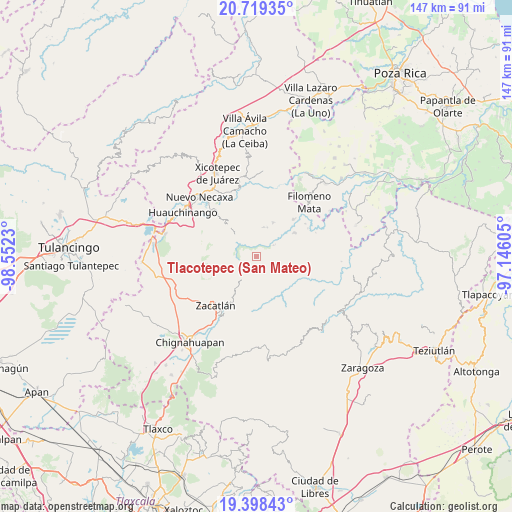
Tlacotepec (San Mateo) GPS coordinates[2]
20° 3' 37.008" North, 97° 50' 57.012" West
| Map corner | latitude | longitude |
|---|---|---|
| Upper-left | 20.71935°, | -98.5523° |
| Center: | 20.06028°, | -97.84917° |
| Lower-right: | 19.39843°, | -97.14605° |
| Map W x H: | 146.9×146.9 km | = 91.3×91.3mi |
| max Lat: | 32.7° ⇑41.7% North |
| Tlacotepec (San Mateo): | 20.06028° |
| min Lat: | ⇓58.3% South 14.53588° |
| min Long | Tlacotepec (San | max Long |
| -117.105° | -97.84917° | -86.73105° |
| W 65.5%⇐ | ⇒34.5% E |
Elevation
Elevation of Tlacotepec (San Mateo) is 1306 m = 4285 ft, and this is 52.3 m = 172 ft above average elevation for this country.
| Max E: |
3497 m = 11473 ft | 52.7% |
| Tlacotepec (San Mateo) | 1306 m 4285 ft | |
| Avg. | 1253.7 m = 4113 ft | |
Min E: |
-1 m = -3 ft | 47.3% |
See also: Mexico elevation on elevation.city.
Geographical zone
Tlacotepec (San Mateo) is located in North Torrid zone (between Equator and Tropic of Cancer). Distance of this Northern Tropic circle is 375.4 km =233.3 mi to North.| Distance of | km | miles | from Tlacotepec (San Mateo) |
|---|---|---|---|
| North Pole | 7776.6 | 4832.2 | to North |
| Arctic Circle | 5170.7 | 3212.9 | to North |
| Tropic Cancer | 375.4 | 233.3 | to North |
| Equator | 2230.5 | 1386 | to South |


Nearby cities:
15 places around Tlacotepec (San Mateo): (largest is in red/bold)
• Ahuacatlán
6.1 km =3.8 mi,  189°
189°
• Altica
5.8 km =3.6 mi,  58°
58°
• Amixtlán
5.4 km =3.4 mi,  104°
104°
• Cuautotola
5.4 km =3.4 mi,  80°
80°
• Cuetzalingo
7.7 km =4.8 mi,  277°
277°
• Jilotzingo
6.4 km =4 mi,  240°
240°
• La Cumbre
6.6 km =4.1 mi,  355°
355°
• Pochálcatl
6.4 km =4 mi,  184°
184°
• San Cristóbal Xochimilpa
6.1 km =3.8 mi, 276°
• San Jerónimo Coaltepec
6.5 km =4 mi,  196°
196°
• San Marcos Eloxochitlán
4.6 km =2.9 mi,  211°
211°
• Tlapacoya
6.9 km =4.3 mi, 358°
• Tlayehualancingo
3.8 km =2.4 mi,  142°
142°
• Tonalapa (Santa Bárbara)
2.3 km =1.4 mi, 175°
• Xochicuautla
4.2 km =2.6 mi,  260°
260°
Sources, notices
• [Note1] Compared only with cities in Mexico existing in our database
• [Src1] Map data: © OpenStreetMap contributors (CC-BY-SA)
• [Src2] Other city data from geonames.org with taken over terms of usage.
• [Src3] Geographical zone / Annual Mean Temperature by Robert A. Rohde @ Wikipedia
