La Toma geodata
La Toma (Veracruz) is a populated place; located in Mexico in America/Mexico_City (GMT-6) time zone. With population of 1,064 people, there are 8203 cities with bigger population in this country. Compared to other cities in Mexico, 55% of cities are located further ↑North; 72.6% of cities are located further ←West and 99.8% of cities have lower elevation than La Toma. Note1


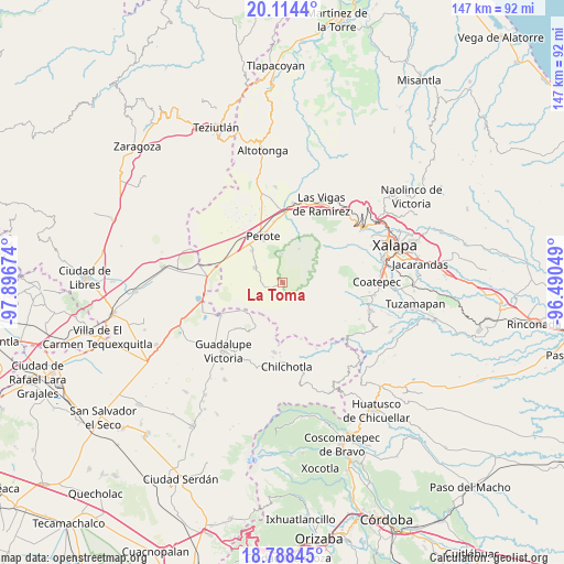
La Toma GPS coordinates[2]
19° 27' 10.008" North, 97° 11' 36.996" West
| Map corner | latitude | longitude |
|---|---|---|
| Upper-left | 20.1144°, | -97.89674° |
| Center: | 19.45278°, | -97.19361° |
| Lower-right: | 18.78845°, | -96.49049° |
| Map W x H: | 147.4×147.4 km | = 91.6×91.6mi |
| max Lat: | 32.7° ⇑55% North |
| La Toma: | 19.45278° |
| min Lat: | ⇓45% South 14.53588° |
| min Long | La Toma | max Long |
| -117.105° | -97.19361° | -86.73105° |
| W 72.6%⇐ | ⇒27.4% E |
Elevation
Elevation of La Toma is 3026 m = 9928 ft, and this is 1772.3 m = 5815 ft above average elevation for this country.
| Max E: |
3497 m = 11473 ft | 0.2% |
| La Toma | 3026 m 9928 ft | |
| Avg. | 1253.7 m = 4113 ft | |
Min E: |
-1 m = -3 ft | 99.8% |
See also: Mexico elevation on elevation.city.
Geographical zone
La Toma is located in North Torrid zone (between Equator and Tropic of Cancer). Distance of this Northern Tropic circle is 443 km =275.3 mi to North.| Distance of | km | miles | from La Toma |
|---|---|---|---|
| North Pole | 7844.1 | 4874.1 | to North |
| Arctic Circle | 5238.2 | 3254.9 | to North |
| Tropic Cancer | 443 | 275.3 | to North |
| Equator | 2162.9 | 1344 | to South |


Nearby cities:
15 places around La Toma: (largest is in red/bold)
• Altamirada
9.6 km =6 mi,  193°
193°
• Apantéopan
10.5 km =6.5 mi,  178°
178°
• Ayahualulco
12.2 km =7.6 mi,  157°
157°
• El Ciprés
9.3 km =5.8 mi, 188°
• El Conejo
9.7 km =6 mi,  25°
25°
• El Escobillo
6.9 km =4.3 mi,  356°
356°
• El Triunfo
4.5 km =2.8 mi,  218°
218°
• Francisco I. Madero
11.6 km =7.2 mi,  315°
315°
• La Gloria
11.3 km =7 mi,  235°
235°
• Libertad
12.3 km =7.6 mi,  328°
328°
• Los Altos
1.2 km =0.7 mi,  230°
230°
• San Isidro
11 km =6.8 mi,  170°
170°
• Tlalconteno
5.6 km =3.5 mi,  265°
265°
• Tonalaco
6.9 km =4.3 mi,  112°
112°
• Xocotepéc
9.8 km =6.1 mi, 165°
Sources, notices
• [Note1] Compared only with cities in Mexico existing in our database
• [Src1] Map data: © OpenStreetMap contributors (CC-BY-SA)
• [Src2] Other city data from geonames.org with taken over terms of usage.
• [Src3] Geographical zone / Annual Mean Temperature by Robert A. Rohde @ Wikipedia
