Los Altos geodata
Los Altos (Veracruz) is a populated place; located in Mexico in America/Mexico_City (GMT-6) time zone. With population of 3,934 people, there are 2320 cities with bigger population in this country. Compared to other cities in Mexico, 55.2% of cities are located further ↑North; 72.4% of cities are located further ←West and 99.4% of cities have lower elevation than Los Altos. Note1


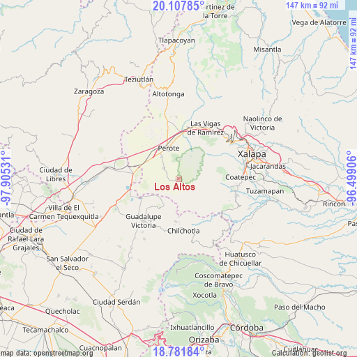
Los Altos GPS coordinates[2]
19° 26' 46.32" North, 97° 12' 7.848" West
| Map corner | latitude | longitude |
|---|---|---|
| Upper-left | 20.10785°, | -97.90531° |
| Center: | 19.4462°, | -97.20218° |
| Lower-right: | 18.78184°, | -96.49906° |
| Map W x H: | 147.4×147.4 km | = 91.6×91.6mi |
| max Lat: | 32.7° ⇑55.2% North |
| Los Altos: | 19.4462° |
| min Lat: | ⇓44.8% South 14.53588° |
| min Long | Los Altos | max Long |
| -117.105° | -97.20218° | -86.73105° |
| W 72.4%⇐ | ⇒27.6% E |
Elevation
Elevation of Los Altos is 2888 m = 9475 ft, and this is 1634.3 m = 5362 ft above average elevation for this country.
| Max E: |
3497 m = 11473 ft | 0.59999999999999% |
| Los Altos | 2888 m 9475 ft | |
| Avg. | 1253.7 m = 4113 ft | |
Min E: |
-1 m = -3 ft | 99.4% |
See also: Mexico elevation on elevation.city.
Geographical zone
Los Altos is located in North Torrid zone (between Equator and Tropic of Cancer). Distance of this Northern Tropic circle is 443.7 km =275.7 mi to North.| Distance of | km | miles | from Los Altos |
|---|---|---|---|
| North Pole | 7844.8 | 4874.5 | to North |
| Arctic Circle | 5239 | 3255.4 | to North |
| Tropic Cancer | 443.7 | 275.7 | to North |
| Equator | 2162.2 | 1343.5 | to South |


Nearby cities:
15 places around Los Altos: (largest is in red/bold)
• Altamirada
8.7 km =5.4 mi,  188°
188°
• Apantéopan
9.9 km =6.2 mi,  173°
173°
• Ayahualulco
12 km =7.5 mi,  152°
152°
• El Ciprés
8.5 km =5.3 mi,  183°
183°
• El Conejo
10.7 km =6.6 mi,  28°
28°
• El Escobillo
7.6 km =4.7 mi,  3°
3°
• El Progreso
11.4 km =7.1 mi,  233°
233°
• El Triunfo
3.3 km =2.1 mi,  214°
214°
• Francisco I. Madero
11.5 km =7.1 mi,  321°
321°
• La Gloria
10.1 km =6.3 mi,  236°
236°
• La Toma
1.2 km =0.7 mi,  50°
50°
• San Isidro
10.5 km =6.5 mi,  164°
164°
• Tlalconteno
4.6 km =2.9 mi,  273°
273°
• Tonalaco
7.5 km =4.7 mi,  104°
104°
• Xocotepéc
9.3 km =5.8 mi, 159°
Sources, notices
• [Note1] Compared only with cities in Mexico existing in our database
• [Src1] Map data: © OpenStreetMap contributors (CC-BY-SA)
• [Src2] Other city data from geonames.org with taken over terms of usage.
• [Src3] Geographical zone / Annual Mean Temperature by Robert A. Rohde @ Wikipedia
