Xocotepéc geodata
Xocotepéc (Puebla) is a populated place; located in Mexico in America/Mexico_City (GMT-6) time zone. With population of 1,677 people, there are 5173 cities with bigger population in this country. Compared to other cities in Mexico, 57.2% of cities are located further ↑North; 72.7% of cities are located further ←West and 89% of cities have lower elevation than Xocotepéc. Note1


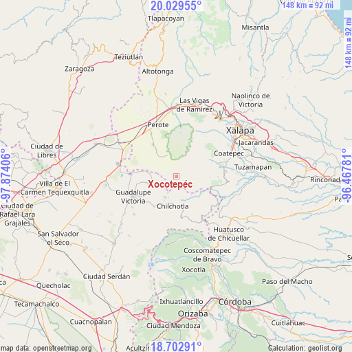
Xocotepéc GPS coordinates[2]
19° 22' 3.288" North, 97° 10' 15.348" West
| Map corner | latitude | longitude |
|---|---|---|
| Upper-left | 20.02955°, | -97.87406° |
| Center: | 19.36758°, | -97.17093° |
| Lower-right: | 18.70291°, | -96.46781° |
| Map W x H: | 147.5×147.5 km | = 91.7×91.7mi |
| max Lat: | 32.7° ⇑57.2% North |
| Xocotepéc: | 19.36758° |
| min Lat: | ⇓42.8% South 14.53588° |
| min Long | Xocotepéc | max Long |
| -117.105° | -97.17093° | -86.73105° |
| W 72.7%⇐ | ⇒27.3% E |
Elevation
Elevation of Xocotepéc is 2373 m = 7785 ft, and this is 1119.3 m = 3672 ft above average elevation for this country.
| Max E: |
3497 m = 11473 ft | 11% |
| Xocotepéc | 2373 m 7785 ft | |
| Avg. | 1253.7 m = 4113 ft | |
Min E: |
-1 m = -3 ft | 89% |
See also: Mexico elevation on elevation.city.
Geographical zone
Xocotepéc is located in North Torrid zone (between Equator and Tropic of Cancer). Distance of this Northern Tropic circle is 452.4 km =281.1 mi to North.| Distance of | km | miles | from Xocotepéc |
|---|---|---|---|
| North Pole | 7853.6 | 4880 | to North |
| Arctic Circle | 5247.7 | 3260.8 | to North |
| Tropic Cancer | 452.4 | 281.1 | to North |
| Equator | 2153.5 | 1338.1 | to South |


Nearby cities:
15 places around Xocotepéc: (largest is in red/bold)
• Altamirada
4.6 km =2.9 mi,  272°
272°
• Apantéopan
2.4 km =1.5 mi,  243°
243°
• Ayahualulco
3 km =1.9 mi,  128°
128°
• El Ciprés
3.8 km =2.4 mi, 274°
• El Triunfo
7.9 km =4.9 mi,  319°
319°
• Ixhuacán de los Reyes
5.8 km =3.6 mi,  103°
103°
• La Providencia
7.4 km =4.6 mi,  207°
207°
• La Toma
9.8 km =6.1 mi,  345°
345°
• La Trinidad
10.1 km =6.3 mi, 206°
• Los Altos
9.3 km =5.8 mi,  339°
339°
• San Antonio Xoquitla
3.1 km =1.9 mi,  168°
168°
• San Isidro
1.5 km =0.9 mi,  200°
200°
• Tlalchy
9.8 km =6.1 mi,  81°
81°
• Tlamanca
10.1 km =6.3 mi,  143°
143°
• Tonalaco
7.9 km =4.9 mi,  30°
30°
Sources, notices
• [Note1] Compared only with cities in Mexico existing in our database
• [Src1] Map data: © OpenStreetMap contributors (CC-BY-SA)
• [Src2] Other city data from geonames.org with taken over terms of usage.
• [Src3] Geographical zone / Annual Mean Temperature by Robert A. Rohde @ Wikipedia
