Los Cerritos geodata
Los Cerritos (Jalisco) is a populated place; located in Mexico in America/Mexico_City (GMT-6) time zone. With population of 638 people, there are 13580 cities with bigger population in this country. Compared to other cities in Mexico, 67.3% of cities are located further ↓South; 85.1% of cities are located further →East and 53.3% of cities have lower elevation than Los Cerritos. Note1


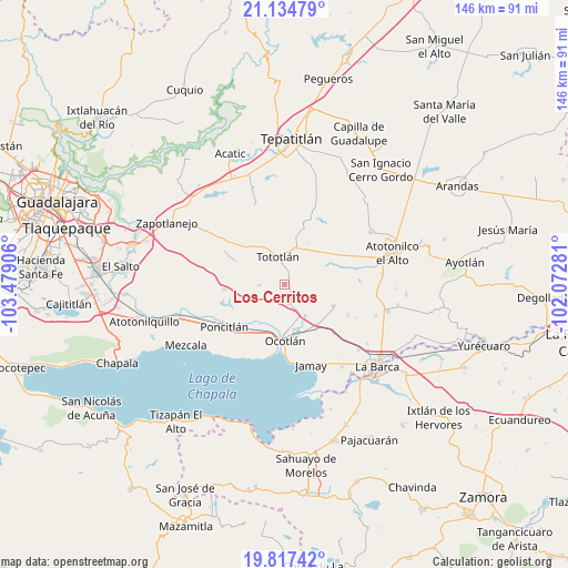
Los Cerritos GPS coordinates[2]
20° 28' 39.072" North, 102° 46' 33.348" West
| Map corner | latitude | longitude |
|---|---|---|
| Upper-left | 21.13479°, | -103.47906° |
| Center: | 20.47752°, | -102.77593° |
| Lower-right: | 19.81742°, | -102.07281° |
| Map W x H: | 146.5×146.5 km | = 91×91mi |
| max Lat: | 32.7° ⇑32.7% North |
| Los Cerritos: | 20.47752° |
| min Lat: | ⇓67.3% South 14.53588° |
| min Long | Los Cerritos | max Long |
| -117.105° | -102.77593° | -86.73105° |
| W 14.9%⇐ | ⇒85.1% E |
Elevation
Elevation of Los Cerritos is 1547 m = 5075 ft, and this is 293.3 m = 962 ft above average elevation for this country.
| Max E: |
3497 m = 11473 ft | 46.7% |
| Los Cerritos | 1547 m 5075 ft | |
| Avg. | 1253.7 m = 4113 ft | |
Min E: |
-1 m = -3 ft | 53.3% |
See also: Mexico elevation on elevation.city.
Geographical zone
Los Cerritos is located in North Torrid zone (between Equator and Tropic of Cancer). Distance of this Northern Tropic circle is 329 km =204.4 mi to North.| Distance of | km | miles | from Los Cerritos |
|---|---|---|---|
| North Pole | 7730.2 | 4803.3 | to North |
| Arctic Circle | 5124.3 | 3184.1 | to North |
| Tropic Cancer | 329 | 204.4 | to North |
| Equator | 2276.9 | 1414.8 | to South |


Nearby cities:
15 places around Los Cerritos: (largest is in red/bold)
• Ahuatlán
13.4 km =8.3 mi,  240°
240°
• Carrozas
4.5 km =2.8 mi,  78°
78°
• Coina Grande
6.2 km =3.9 mi,  33°
33°
• El Sauz
2.7 km =1.7 mi,  273°
273°
• Joconoxtle (La Tuna)
10.7 km =6.6 mi,  105°
105°
• La Noria
7.8 km =4.8 mi,  251°
251°
• Nuevo Refugio de Afuera (Nuevo Refugio)
10.7 km =6.6 mi,  42°
42°
• Ocotlán
13.6 km =8.5 mi,  178°
178°
• Otatlán
5 km =3.1 mi,  215°
215°
• San Isidro
12.2 km =7.6 mi, 30°
• San Luis de Agua Caliente
11.6 km =7.2 mi,  205°
205°
• San Martín de Zula
9.1 km =5.7 mi,  146°
146°
• San Vicente
13.8 km =8.6 mi, 113°
• Santa Clara de Zula
9.9 km =6.2 mi,  140°
140°
• Tototlán
7.4 km =4.6 mi,  346°
346°
Sources, notices
• [Note1] Compared only with cities in Mexico existing in our database
• [Src1] Map data: © OpenStreetMap contributors (CC-BY-SA)
• [Src2] Other city data from geonames.org with taken over terms of usage.
• [Src3] Geographical zone / Annual Mean Temperature by Robert A. Rohde @ Wikipedia
