Carrozas geodata
Carrozas (Jalisco) is a populated place; located in Mexico in America/Mexico_City (GMT-6) time zone. With population of 719 people, there are 12132 cities with bigger population in this country. Compared to other cities in Mexico, 67.5% of cities are located further ↓South; 84.9% of cities are located further →East and 52.8% of cities have lower elevation than Carrozas. Note1


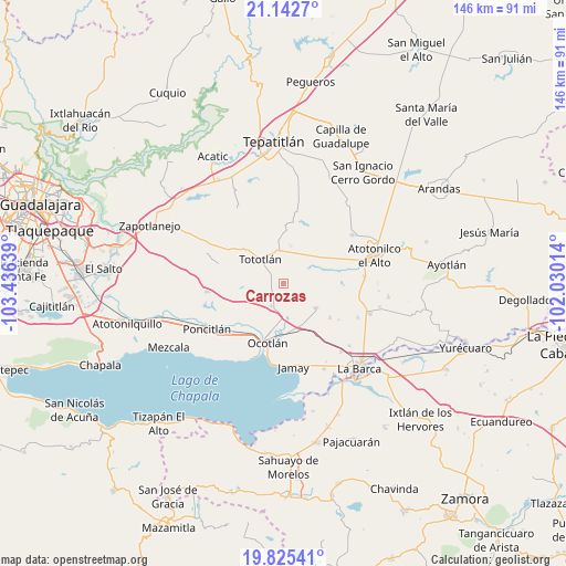
Carrozas GPS coordinates[2]
20° 29' 7.692" North, 102° 43' 59.736" West
| Map corner | latitude | longitude |
|---|---|---|
| Upper-left | 21.1427°, | -103.43639° |
| Center: | 20.48547°, | -102.73326° |
| Lower-right: | 19.82541°, | -102.03014° |
| Map W x H: | 146.5×146.5 km | = 91×91mi |
| max Lat: | 32.7° ⇑32.5% North |
| Carrozas: | 20.48547° |
| min Lat: | ⇓67.5% South 14.53588° |
| min Long | Carrozas | max Long |
| -117.105° | -102.73326° | -86.73105° |
| W 15.1%⇐ | ⇒84.9% E |
Elevation
Elevation of Carrozas is 1538 m = 5046 ft, and this is 284.3 m = 933 ft above average elevation for this country.
| Max E: |
3497 m = 11473 ft | 47.2% |
| Carrozas | 1538 m 5046 ft | |
| Avg. | 1253.7 m = 4113 ft | |
Min E: |
-1 m = -3 ft | 52.8% |
See also: Mexico elevation on elevation.city.
Geographical zone
Carrozas is located in North Torrid zone (between Equator and Tropic of Cancer). Distance of this Northern Tropic circle is 328.1 km =203.9 mi to North.| Distance of | km | miles | from Carrozas |
|---|---|---|---|
| North Pole | 7729.3 | 4802.8 | to North |
| Arctic Circle | 5123.4 | 3183.5 | to North |
| Tropic Cancer | 328.1 | 203.9 | to North |
| Equator | 2277.8 | 1415.4 | to South |


Nearby cities:
15 places around Carrozas: (largest is in red/bold)
• Coina Grande
4.4 km =2.7 mi,  346°
346°
• El Sauz
7.2 km =4.5 mi,  264°
264°
• Joconoxtle (La Tuna)
7 km =4.3 mi,  121°
121°
• La Noria
12.3 km =7.6 mi,  253°
253°
• Los Cerritos
4.5 km =2.8 mi, 258°
• Nuevo Refugio de Afuera (Nuevo Refugio)
7.6 km =4.7 mi,  21°
21°
• Otatlán
8.9 km =5.5 mi,  236°
236°
• Rancho Viejo del Refugio
10.6 km =6.6 mi,  111°
111°
• San Antonio de Fernández
14.1 km =8.8 mi,  58°
58°
• San Isidro
9.8 km =6.1 mi,  10°
10°
• San Martín de Zula
8.5 km =5.3 mi,  176°
176°
• San Miguel de la Paz
14.7 km =9.1 mi,  150°
150°
• San Vicente
10.4 km =6.5 mi,  127°
127°
• Santa Clara de Zula
8.7 km =5.4 mi,  168°
168°
• Tototlán
8.8 km =5.5 mi,  315°
315°
Sources, notices
• [Note1] Compared only with cities in Mexico existing in our database
• [Src1] Map data: © OpenStreetMap contributors (CC-BY-SA)
• [Src2] Other city data from geonames.org with taken over terms of usage.
• [Src3] Geographical zone / Annual Mean Temperature by Robert A. Rohde @ Wikipedia
