San Pedro la Joya geodata
San Pedro la Joya (Puebla) is a populated place; located in Mexico in America/Mexico_City (GMT-6) time zone. With population of 1,708 people, there are 5088 cities with bigger population in this country. Compared to other cities in Mexico, 63.6% of cities are located further ↑North; 65.6% of cities are located further ←West and 88.8% of cities have lower elevation than San Pedro la Joya. Note1


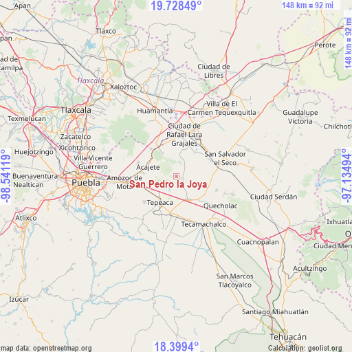
San Pedro la Joya GPS coordinates[2]
19° 3' 55.008" North, 97° 50' 17.016" West
| Map corner | latitude | longitude |
|---|---|---|
| Upper-left | 19.72849°, | -98.54119° |
| Center: | 19.06528°, | -97.83806° |
| Lower-right: | 18.3994°, | -97.13494° |
| Map W x H: | 147.8×147.8 km | = 91.8×91.8mi |
| max Lat: | 32.7° ⇑63.6% North |
| San Pedro la Joya: | 19.06528° |
| min Lat: | ⇓36.4% South 14.53588° |
| min Long | San Pedro la Jo | max Long |
| -117.105° | -97.83806° | -86.73105° |
| W 65.6%⇐ | ⇒34.4% E |
Elevation
Elevation of San Pedro la Joya is 2365 m = 7759 ft, and this is 1111.3 m = 3646 ft above average elevation for this country.
| Max E: |
3497 m = 11473 ft | 11.2% |
| San Pedro la Joya | 2365 m 7759 ft | |
| Avg. | 1253.7 m = 4113 ft | |
Min E: |
-1 m = -3 ft | 88.8% |
See also: Mexico elevation on elevation.city.
Geographical zone
San Pedro la Joya is located in North Torrid zone (between Equator and Tropic of Cancer). Distance of this Northern Tropic circle is 486.1 km =302 mi to North.| Distance of | km | miles | from San Pedro la Joya |
|---|---|---|---|
| North Pole | 7887.2 | 4900.9 | to North |
| Arctic Circle | 5281.3 | 3281.6 | to North |
| Tropic Cancer | 486.1 | 302 | to North |
| Equator | 2119.9 | 1317.2 | to South |


Nearby cities:
15 places around San Pedro la Joya: (largest is in red/bold)
• Benito Juárez
6.6 km =4.1 mi,  197°
197°
• Carmen Serdán
4.2 km =2.6 mi,  139°
139°
• Guadalupe Morelos
5.7 km =3.5 mi, 141°
• Hernández
5.1 km =3.2 mi,  51°
51°
• Los Reyes de Ocampo
1.6 km =1 mi,  183°
183°
• Manuel Ávila Camacho (La Cima)
7.5 km =4.7 mi,  22°
22°
• Nicolás Bravo
5.7 km =3.5 mi,  163°
163°
• San Cristóbal Hidalgo
5.6 km =3.5 mi,  148°
148°
• San Felipe Tenextepec
5.4 km =3.4 mi,  225°
225°
• San Francisco Buenavista
4.3 km =2.7 mi, 176°
• San Lorenzo Joya de Rodríguez
2 km =1.2 mi, 233°
• San Miguel
1.9 km =1.2 mi,  280°
280°
• San Sebastián Teteles
6.2 km =3.9 mi,  126°
126°
• Santa Cuz del Bosque
7.7 km =4.8 mi,  4°
4°
• Vincente Guerrero
2.3 km =1.4 mi,  108°
108°
Sources, notices
• [Note1] Compared only with cities in Mexico existing in our database
• [Src1] Map data: © OpenStreetMap contributors (CC-BY-SA)
• [Src2] Other city data from geonames.org with taken over terms of usage.
• [Src3] Geographical zone / Annual Mean Temperature by Robert A. Rohde @ Wikipedia
