Vincente Guerrero geodata
Vincente Guerrero (Puebla) is a populated place; located in Mexico in America/Mexico_City (GMT-6) time zone. With population of 923 people, there are 9459 cities with bigger population in this country. Compared to other cities in Mexico, 63.7% of cities are located further ↑North; 65.9% of cities are located further ←West and 86.6% of cities have lower elevation than Vincente Guerrero. Note1


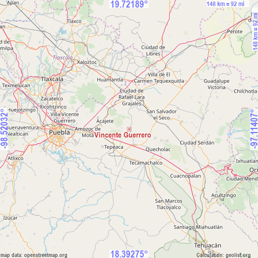
Vincente Guerrero GPS coordinates[2]
19° 3' 31.14" North, 97° 49' 1.884" West
| Map corner | latitude | longitude |
|---|---|---|
| Upper-left | 19.72189°, | -98.52032° |
| Center: | 19.05865°, | -97.81719° |
| Lower-right: | 18.39275°, | -97.11407° |
| Map W x H: | 147.8×147.8 km | = 91.8×91.8mi |
| max Lat: | 32.7° ⇑63.7% North |
| Vincente Guerrero: | 19.05865° |
| min Lat: | ⇓36.3% South 14.53588° |
| min Long | Vincente Guerre | max Long |
| -117.105° | -97.81719° | -86.73105° |
| W 65.9%⇐ | ⇒34.1% E |
Elevation
Elevation of Vincente Guerrero is 2299 m = 7543 ft, and this is 1045.3 m = 3429 ft above average elevation for this country.
| Max E: |
3497 m = 11473 ft | 13.4% |
| Vincente Guerrero | 2299 m 7543 ft | |
| Avg. | 1253.7 m = 4113 ft | |
Min E: |
-1 m = -3 ft | 86.6% |
See also: Mexico elevation on elevation.city.
Geographical zone
Vincente Guerrero is located in North Torrid zone (between Equator and Tropic of Cancer). Distance of this Northern Tropic circle is 486.8 km =302.5 mi to North.| Distance of | km | miles | from Vincente Guerrero |
|---|---|---|---|
| North Pole | 7887.9 | 4901.3 | to North |
| Arctic Circle | 5282.1 | 3282.1 | to North |
| Tropic Cancer | 486.8 | 302.5 | to North |
| Equator | 2119.1 | 1316.7 | to South |


Nearby cities:
15 places around Vincente Guerrero: (largest is in red/bold)
• Benito Juárez
6.9 km =4.3 mi,  217°
217°
• Carmen Serdán
2.5 km =1.6 mi,  167°
167°
• Guadalupe Morelos
3.9 km =2.4 mi,  159°
159°
• Hernández
4.3 km =2.7 mi,  25°
25°
• La Ermita
7.4 km =4.6 mi,  24°
24°
• Los Reyes de Ocampo
2.4 km =1.5 mi,  249°
249°
• Nicolás Bravo
4.7 km =2.9 mi,  187°
187°
• San Cristóbal Hidalgo
4.1 km =2.5 mi, 169°
• San Cristóbal los Nava
7.2 km =4.5 mi, 192°
• San Felipe Tenextepec
6.8 km =4.2 mi,  243°
243°
• San Francisco Buenavista
4.1 km =2.5 mi,  208°
208°
• San Lorenzo Joya de Rodríguez
3.8 km =2.4 mi,  262°
262°
• San Miguel
4.2 km =2.6 mi,  284°
284°
• San Pedro la Joya
2.3 km =1.4 mi,  288°
288°
• San Sebastián Teteles
4.1 km =2.5 mi,  135°
135°
Sources, notices
• [Note1] Compared only with cities in Mexico existing in our database
• [Src1] Map data: © OpenStreetMap contributors (CC-BY-SA)
• [Src2] Other city data from geonames.org with taken over terms of usage.
• [Src3] Geographical zone / Annual Mean Temperature by Robert A. Rohde @ Wikipedia
