El Fresno geodata
El Fresno (Veracruz) is a populated place; located in Mexico in America/Mexico_City (GMT-6) time zone. With population of 969 people, there are 8976 cities with bigger population in this country. Compared to other cities in Mexico, 51.1% of cities are located further ↑North; 75.1% of cities are located further ←West and 62.7% of cities have lower elevation than El Fresno. Note1


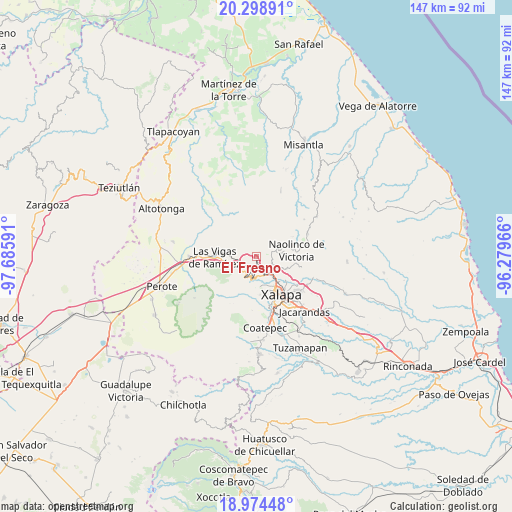
El Fresno GPS coordinates[2]
19° 38' 17.016" North, 96° 58' 58.008" West
| Map corner | latitude | longitude |
|---|---|---|
| Upper-left | 20.29891°, | -97.68591° |
| Center: | 19.63806°, | -96.98278° |
| Lower-right: | 18.97448°, | -96.27966° |
| Map W x H: | 147.3×147.3 km | = 91.5×91.5mi |
| max Lat: | 32.7° ⇑51.1% North |
| El Fresno: | 19.63806° |
| min Lat: | ⇓48.9% South 14.53588° |
| min Long | El Fresno | max Long |
| -117.105° | -96.98278° | -86.73105° |
| W 75.1%⇐ | ⇒24.9% E |
Elevation
Elevation of El Fresno is 1773 m = 5817 ft, and this is 519.3 m = 1704 ft above average elevation for this country.
| Max E: |
3497 m = 11473 ft | 37.3% |
| El Fresno | 1773 m 5817 ft | |
| Avg. | 1253.7 m = 4113 ft | |
Min E: |
-1 m = -3 ft | 62.7% |
See also: Mexico elevation on elevation.city.
Geographical zone
El Fresno is located in North Torrid zone (between Equator and Tropic of Cancer). Distance of this Northern Tropic circle is 422.4 km =262.5 mi to North.| Distance of | km | miles | from El Fresno |
|---|---|---|---|
| North Pole | 7823.5 | 4861.3 | to North |
| Arctic Circle | 5217.6 | 3242.1 | to North |
| Tropic Cancer | 422.4 | 262.5 | to North |
| Equator | 2183.5 | 1356.8 | to South |


Nearby cities:
15 places around El Fresno: (largest is in red/bold)
• Acajete
6.4 km =4 mi,  206°
206°
• Atlapa Chico
5.9 km =3.7 mi,  319°
319°
• Coacoatzintla
4.7 km =2.9 mi,  71°
71°
• Duraznal
2.4 km =1.5 mi,  337°
337°
• El Rosario
5.6 km =3.5 mi,  164°
164°
• Etlantepec
5.3 km =3.3 mi,  355°
355°
• Jilotepec
4.4 km =2.7 mi,  131°
131°
• Joya Chica
6.5 km =4 mi,  218°
218°
• La Joya
5.5 km =3.4 mi,  236°
236°
• Linderos
2 km =1.2 mi,  142°
142°
• Los Planes (Cerro Gordo)
6.5 km =4 mi,  64°
64°
• Piedra de Agua
4.3 km =2.7 mi,  151°
151°
• Piletas
5.6 km =3.5 mi,  175°
175°
• Rafael Lucio
5.1 km =3.2 mi,  188°
188°
• Tlacolulan
3.8 km =2.4 mi,  327°
327°
Sources, notices
• [Note1] Compared only with cities in Mexico existing in our database
• [Src1] Map data: © OpenStreetMap contributors (CC-BY-SA)
• [Src2] Other city data from geonames.org with taken over terms of usage.
• [Src3] Geographical zone / Annual Mean Temperature by Robert A. Rohde @ Wikipedia
