Coacoatzintla geodata
Coacoatzintla (Veracruz) is a seat of a second-order administrative division; located in Mexico in America/Mexico_City (GMT-6) time zone. With population of 6,832 people, there are 1367 cities with bigger population in this country. Compared to other cities in Mexico, 50.9% of cities are located further ↑North; 75.7% of cities are located further ←West and 50.4% of cities have lower elevation than Coacoatzintla. Note1


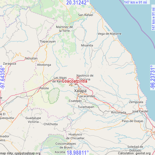
Coacoatzintla GPS coordinates[2]
19° 39' 5.868" North, 96° 56' 25.548" West
| Map corner | latitude | longitude |
|---|---|---|
| Upper-left | 20.31242°, | -97.64356° |
| Center: | 19.65163°, | -96.94043° |
| Lower-right: | 18.98811°, | -96.23731° |
| Map W x H: | 147.2×147.3 km | = 91.5×91.5mi |
| max Lat: | 32.7° ⇑50.9% North |
| Coacoatzintla: | 19.65163° |
| min Lat: | ⇓49.1% South 14.53588° |
| min Long | Coacoatzintla | max Long |
| -117.105° | -96.94043° | -86.73105° |
| W 75.7%⇐ | ⇒24.3% E |
Elevation
Elevation of Coacoatzintla is 1451 m = 4760 ft, and this is 197.3 m = 647 ft above average elevation for this country.
| Max E: |
3497 m = 11473 ft | 49.6% |
| Coacoatzintla | 1451 m 4760 ft | |
| Avg. | 1253.7 m = 4113 ft | |
Min E: |
-1 m = -3 ft | 50.4% |
See also: Mexico elevation on elevation.city.
Geographical zone
Coacoatzintla is located in North Torrid zone (between Equator and Tropic of Cancer). Distance of this Northern Tropic circle is 420.9 km =261.5 mi to North.| Distance of | km | miles | from Coacoatzintla |
|---|---|---|---|
| North Pole | 7822 | 4860.4 | to North |
| Arctic Circle | 5216.1 | 3241.1 | to North |
| Tropic Cancer | 420.9 | 261.5 | to North |
| Equator | 2185.1 | 1357.8 | to South |


Nearby cities:
15 places around Coacoatzintla: (largest is in red/bold)
• Duraznal
5.4 km =3.4 mi,  277°
277°
• El Fresno
4.7 km =2.9 mi,  251°
251°
• El Pueblito (Garbanzal)
6.6 km =4.1 mi,  165°
165°
• Etlantepec
6.1 km =3.8 mi,  308°
308°
• Jilotepec
4.6 km =2.9 mi,  194°
194°
• La Concepción
6.6 km =4.1 mi,  140°
140°
• Las Lomas
4.4 km =2.7 mi, 135°
• Linderos
4.5 km =2.8 mi,  225°
225°
• Los Planes (Cerro Gordo)
1.9 km =1.2 mi,  47°
47°
• Piedra de Agua
5.8 km =3.6 mi,  204°
204°
• Piedras Grandes
6 km =3.7 mi,  25°
25°
• Puentezuelos
7 km =4.3 mi,  11°
11°
• Tlacolulan
6.7 km =4.2 mi, 284°
• Tonayán
4 km =2.5 mi, 30°
• Xaltepec
5.8 km =3.6 mi, 171°
Sources, notices
• [Note1] Compared only with cities in Mexico existing in our database
• [Src1] Map data: © OpenStreetMap contributors (CC-BY-SA)
• [Src2] Other city data from geonames.org with taken over terms of usage.
• [Src3] Geographical zone / Annual Mean Temperature by Robert A. Rohde @ Wikipedia
