Tecozajca (Tepehuaje) geodata
Tecozajca (Tepehuaje) (Guerrero) is a populated place; located in Mexico in America/Mexico_City (GMT-6) time zone. With population of 953 people, there are 9139 cities with bigger population in this country. Compared to other cities in Mexico, 80.4% of cities are located further ↑North; 52.5% of cities are located further ←West and 54% of cities have higher elevation than Tecozajca (Tepehuaje). Note1
Current local time in Tecozajca (Tepehuaje):
08:29 AM, WednesdayDifference from your time zone: hours


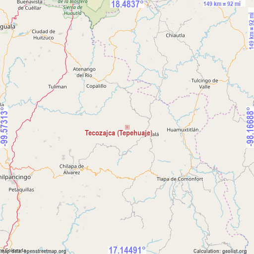
Tecozajca (Tepehuaje) GPS coordinates[2]
17° 48' 56.016" North, 98° 52' 12" West
| Map corner | latitude | longitude |
|---|---|---|
| Upper-left | 18.4837°, | -99.57313° |
| Center: | 17.81556°, | -98.87° |
| Lower-right: | 17.14491°, | -98.16688° |
| Map W x H: | 148.9×148.9 km | = 92.5×92.5mi |
| max Lat: | 32.7° ⇑80.4% North |
| Tecozajca (Tepehuaje): | 17.81556° |
| min Lat: | ⇓19.6% South 14.53588° |
| min Long | Tecozajca (Tepe | max Long |
| -117.105° | -98.87° | -86.73105° |
| W 52.5%⇐ | ⇒47.5% E |
Elevation
Elevation of Tecozajca (Tepehuaje) is 1242 m = 4075 ft, and this is 11.7 m = 38 ft below average elevation for this country.
| Max E: |
3497 m = 11473 ft | 54% |
| Avg. | 1253.7 m = 4113 ft | |
| Tecozajca (Tepehuaje) | 1242 m = 4075 ft | |
Min E: |
-1 m = -3 ft | 46% |
See also: Mexico elevation on elevation.city.
Geographical zone
Tecozajca (Tepehuaje) is located in North Torrid zone (between Equator and Tropic of Cancer). Distance of this Northern Tropic circle is 625 km =388.4 mi to North.| Distance of | km | miles | from Tecozajca (Tepehuaje) |
|---|---|---|---|
| North Pole | 8026.2 | 4987.2 | to North |
| Arctic Circle | 5420.3 | 3368 | to North |
| Tropic Cancer | 625 | 388.4 | to North |
| Equator | 1980.9 | 1230.9 | to South |


Nearby cities:
15 places around Tecozajca (Tepehuaje): (largest is in red/bold)
• Ahuacatlán
19.1 km =11.9 mi,  55°
55°
• Ahuacuotzingo
13.2 km =8.2 mi,  211°
211°
• Alpuyecancingo de las Montañas
16.2 km =10.1 mi,  173°
173°
• Amatlicha
7.1 km =4.4 mi,  79°
79°
• La Libertad
15.9 km =9.9 mi,  119°
119°
• Mitlancingo
11.9 km =7.4 mi,  278°
278°
• Olinalá
14.4 km =8.9 mi,  106°
106°
• Ostoyahualco
15.2 km =9.4 mi,  222°
222°
• Pochutla
17.7 km =11 mi,  189°
189°
• Rincón de Cozahuapa
8.5 km =5.3 mi, 279°
• Tecolcuautla
8.9 km =5.5 mi,  248°
248°
• Tepetlacingo
16.3 km =10.1 mi,  44°
44°
• Tepetlatipa
16.5 km =10.3 mi,  266°
266°
• Xitopontla
11.9 km =7.4 mi, 166°
• Xocoyolzintla
16.5 km =10.3 mi,  226°
226°
Sources, notices
• [Note1] Compared only with cities in Mexico existing in our database
• [Src1] Map data: © OpenStreetMap contributors (CC-BY-SA)
• [Src2] Other city data from geonames.org with taken over terms of usage.
• [Src3] Geographical zone / Annual Mean Temperature by Robert A. Rohde @ Wikipedia
