Xocoyolzintla geodata
Xocoyolzintla (Guerrero) is a populated place; located in Mexico in America/Mexico_City (GMT-6) time zone. With population of 1,566 people, there are 5516 cities with bigger population in this country. Compared to other cities in Mexico, 81.2% of cities are located further ↑North; 50.5% of cities are located further ←West and 53% of cities have higher elevation than Xocoyolzintla. Note1


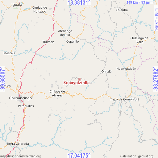
Xocoyolzintla GPS coordinates[2]
17° 42' 46.008" North, 98° 58' 54.984" West
| Map corner | latitude | longitude |
|---|---|---|
| Upper-left | 18.38131°, | -99.68507° |
| Center: | 17.71278°, | -98.98194° |
| Lower-right: | 17.04175°, | -98.27882° |
| Map W x H: | 148.9×148.9 km | = 92.5×92.5mi |
| max Lat: | 32.7° ⇑81.2% North |
| Xocoyolzintla: | 17.71278° |
| min Lat: | ⇓18.8% South 14.53588° |
| min Long | Xocoyolzintla | max Long |
| -117.105° | -98.98194° | -86.73105° |
| W 50.5%⇐ | ⇒49.5% E |
Elevation
Elevation of Xocoyolzintla is 1290 m = 4232 ft, and this is 36.3 m = 119 ft above average elevation for this country.
| Max E: |
3497 m = 11473 ft | 53% |
| Xocoyolzintla | 1290 m 4232 ft | |
| Avg. | 1253.7 m = 4113 ft | |
Min E: |
-1 m = -3 ft | 47% |
See also: Mexico elevation on elevation.city.
Geographical zone
Xocoyolzintla is located in North Torrid zone (between Equator and Tropic of Cancer). Distance of this Northern Tropic circle is 636.4 km =395.4 mi to North.| Distance of | km | miles | from Xocoyolzintla |
|---|---|---|---|
| North Pole | 8037.6 | 4994.3 | to North |
| Arctic Circle | 5431.7 | 3375.1 | to North |
| Tropic Cancer | 636.4 | 395.4 | to North |
| Equator | 1969.5 | 1223.8 | to South |


Nearby cities:
15 places around Xocoyolzintla: (largest is in red/bold)
• Ahuacuotzingo
5 km =3.1 mi,  88°
88°
• Ajuatetla
12.4 km =7.7 mi,  308°
308°
• Alpuyecancingo de las Montañas
14.5 km =9 mi,  108°
108°
• Mitlancingo
13.1 km =8.1 mi,  0°
0°
• Ostoyahualco
1.5 km =0.9 mi,  80°
80°
• Oztotitlán
6.4 km =4 mi,  225°
225°
• Pochutla
10.7 km =6.6 mi,  123°
123°
• Rincón de Cozahuapa
13.4 km =8.3 mi,  14°
14°
• Santa Catarina (Santa Catarina las Joyas)
12.3 km =7.6 mi,  289°
289°
• Tecoanapa
7.7 km =4.8 mi,  236°
236°
• Tecolcuautla
8.9 km =5.5 mi,  23°
23°
• Tepetlatipa
11.3 km =7 mi,  336°
336°
• Tlalcomulco
6.3 km =3.9 mi,  265°
265°
• Xitopontla
14.7 km =9.1 mi, 90°
• Yetlancingo
14.2 km =8.8 mi, 273°
Sources, notices
• [Note1] Compared only with cities in Mexico existing in our database
• [Src1] Map data: © OpenStreetMap contributors (CC-BY-SA)
• [Src2] Other city data from geonames.org with taken over terms of usage.
• [Src3] Geographical zone / Annual Mean Temperature by Robert A. Rohde @ Wikipedia
