Ostoyahualco geodata
Ostoyahualco (Guerrero) is a populated place; located in Mexico in America/Mexico_City (GMT-6) time zone. With population of 689 people, there are 12616 cities with bigger population in this country. Compared to other cities in Mexico, 81.2% of cities are located further ↑North; 50.7% of cities are located further ←West and 52.3% of cities have higher elevation than Ostoyahualco. Note1


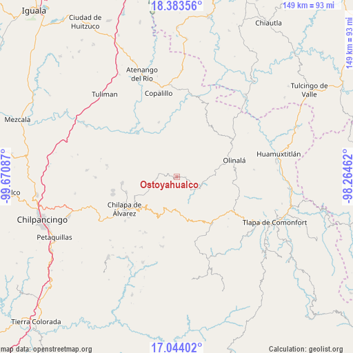
Ostoyahualco GPS coordinates[2]
17° 42' 54.144" North, 98° 58' 3.864" West
| Map corner | latitude | longitude |
|---|---|---|
| Upper-left | 18.38356°, | -99.67087° |
| Center: | 17.71504°, | -98.96774° |
| Lower-right: | 17.04402°, | -98.26462° |
| Map W x H: | 148.9×148.9 km | = 92.5×92.5mi |
| max Lat: | 32.7° ⇑81.2% North |
| Ostoyahualco: | 17.71504° |
| min Lat: | ⇓18.8% South 14.53588° |
| min Long | Ostoyahualco | max Long |
| -117.105° | -98.96774° | -86.73105° |
| W 50.7%⇐ | ⇒49.3% E |
Elevation
Elevation of Ostoyahualco is 1323 m = 4341 ft, and this is 69.3 m = 227 ft above average elevation for this country.
| Max E: |
3497 m = 11473 ft | 52.3% |
| Ostoyahualco | 1323 m 4341 ft | |
| Avg. | 1253.7 m = 4113 ft | |
Min E: |
-1 m = -3 ft | 47.7% |
See also: Mexico elevation on elevation.city.
Geographical zone
Ostoyahualco is located in North Torrid zone (between Equator and Tropic of Cancer). Distance of this Northern Tropic circle is 636.2 km =395.3 mi to North.| Distance of | km | miles | from Ostoyahualco |
|---|---|---|---|
| North Pole | 8037.3 | 4994.1 | to North |
| Arctic Circle | 5431.4 | 3374.9 | to North |
| Tropic Cancer | 636.2 | 395.3 | to North |
| Equator | 1969.7 | 1223.9 | to South |


Nearby cities:
15 places around Ostoyahualco: (largest is in red/bold)
• Ahuacuotzingo
3.5 km =2.2 mi,  91°
91°
• Ajuatetla
13.5 km =8.4 mi,  303°
303°
• Alpuyecancingo de las Montañas
13.2 km =8.2 mi,  111°
111°
• Mitlancingo
12.9 km =8 mi,  353°
353°
• Oztotitlán
7.7 km =4.8 mi,  231°
231°
• Petatlán
15.1 km =9.4 mi,  188°
188°
• Pochutla
9.7 km =6 mi,  130°
130°
• Rincón de Cozahuapa
12.8 km =8 mi,  8°
8°
• Santa Catarina (Santa Catarina las Joyas)
13.7 km =8.5 mi,  286°
286°
• Tecoanapa
9.2 km =5.7 mi,  240°
240°
• Tecolcuautla
8.2 km =5.1 mi, 14°
• Tepetlatipa
11.8 km =7.3 mi,  328°
328°
• Tlalcomulco
7.8 km =4.8 mi,  264°
264°
• Xitopontla
13.2 km =8.2 mi, 91°
• Xocoyolzintla
1.5 km =0.9 mi, 260°
Sources, notices
• [Note1] Compared only with cities in Mexico existing in our database
• [Src1] Map data: © OpenStreetMap contributors (CC-BY-SA)
• [Src2] Other city data from geonames.org with taken over terms of usage.
• [Src3] Geographical zone / Annual Mean Temperature by Robert A. Rohde @ Wikipedia
