Ahuacatlán geodata
Ahuacatlán (Guerrero) is a populated place; located in Mexico in America/Mexico_City (GMT-6) time zone. With population of 805 people, there are 10845 cities with bigger population in this country. Compared to other cities in Mexico, 79.6% of cities are located further ↑North; 54.8% of cities are located further ←West and 55.3% of cities have lower elevation than Ahuacatlán. Note1


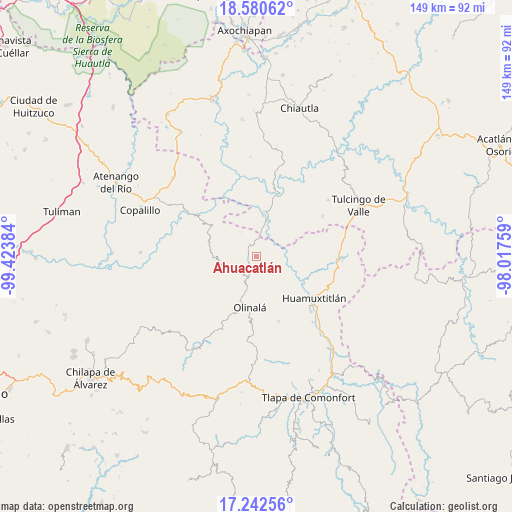
Ahuacatlán GPS coordinates[2]
17° 54' 46.26" North, 98° 43' 14.556" West
| Map corner | latitude | longitude |
|---|---|---|
| Upper-left | 18.58062°, | -99.42384° |
| Center: | 17.91285°, | -98.72071° |
| Lower-right: | 17.24256°, | -98.01759° |
| Map W x H: | 148.8×148.8 km | = 92.5×92.5mi |
| max Lat: | 32.7° ⇑79.6% North |
| Ahuacatlán: | 17.91285° |
| min Lat: | ⇓20.4% South 14.53588° |
| min Long | Ahuacatlán | max Long |
| -117.105° | -98.72071° | -86.73105° |
| W 54.8%⇐ | ⇒45.2% E |
Elevation
Elevation of Ahuacatlán is 1597 m = 5240 ft, and this is 343.3 m = 1126 ft above average elevation for this country.
| Max E: |
3497 m = 11473 ft | 44.7% |
| Ahuacatlán | 1597 m 5240 ft | |
| Avg. | 1253.7 m = 4113 ft | |
Min E: |
-1 m = -3 ft | 55.3% |
See also: Mexico elevation on elevation.city.
Geographical zone
Ahuacatlán is located in North Torrid zone (between Equator and Tropic of Cancer). Distance of this Northern Tropic circle is 614.2 km =381.6 mi to North.| Distance of | km | miles | from Ahuacatlán |
|---|---|---|---|
| North Pole | 8015.3 | 4980.5 | to North |
| Arctic Circle | 5409.5 | 3361.3 | to North |
| Tropic Cancer | 614.2 | 381.6 | to North |
| Equator | 1991.7 | 1237.6 | to South |


Nearby cities:
15 places around Ahuacatlán: (largest is in red/bold)
• Amatlicha
12.9 km =8 mi,  222°
222°
• Chiaucingo
19.2 km =11.9 mi,  172°
172°
• Coacalco
18.5 km =11.5 mi,  17°
17°
• Cualác
19.9 km =12.4 mi,  161°
161°
• Huamuxtitlán
20.5 km =12.7 mi,  126°
126°
• Ixcamilpa
13 km =8.1 mi,  11°
11°
• La Libertad
18.7 km =11.6 mi,  186°
186°
• Olinalá
15.1 km =9.4 mi, 187°
• San Antonio Coyahuacán
7.1 km =4.4 mi,  142°
142°
• San Miguel Comitlipa
18.8 km =11.7 mi,  71°
71°
• Santa Cruz Lomalapa (Lomalapa)
5.2 km =3.2 mi,  87°
87°
• Tecozajca (Tepehuaje)
19.1 km =11.9 mi,  235°
235°
• Tepetlacingo
4.5 km =2.8 mi,  280°
280°
• Toltecamila
12.1 km =7.5 mi,  63°
63°
• Zumpango
4.7 km =2.9 mi, 58°
Sources, notices
• [Note1] Compared only with cities in Mexico existing in our database
• [Src1] Map data: © OpenStreetMap contributors (CC-BY-SA)
• [Src2] Other city data from geonames.org with taken over terms of usage.
• [Src3] Geographical zone / Annual Mean Temperature by Robert A. Rohde @ Wikipedia
