Pochutla geodata
Pochutla (Guerrero) is a populated place; located in Mexico in America/Mexico_City (GMT-6) time zone. With population of 1,201 people, there are 7237 cities with bigger population in this country. Compared to other cities in Mexico, 81.7% of cities are located further ↑North; 52% of cities are located further ←West and 56.1% of cities have higher elevation than Pochutla. Note1


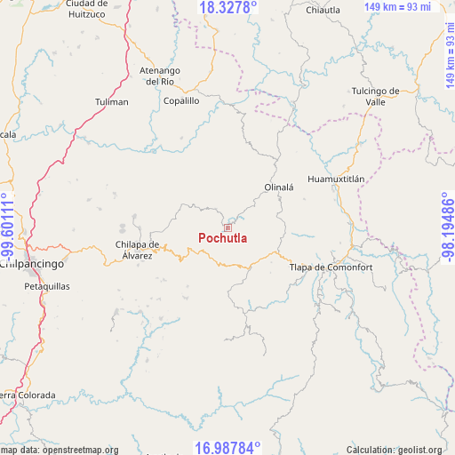
Pochutla GPS coordinates[2]
17° 39' 32.652" North, 98° 53' 52.728" West
| Map corner | latitude | longitude |
|---|---|---|
| Upper-left | 18.3278°, | -99.60111° |
| Center: | 17.65907°, | -98.89798° |
| Lower-right: | 16.98784°, | -98.19486° |
| Map W x H: | 149×149 km | = 92.6×92.6mi |
| max Lat: | 32.7° ⇑81.7% North |
| Pochutla: | 17.65907° |
| min Lat: | ⇓18.3% South 14.53588° |
| min Long | Pochutla | max Long |
| -117.105° | -98.89798° | -86.73105° |
| W 52%⇐ | ⇒48% E |
Elevation
Elevation of Pochutla is 1156 m = 3793 ft, and this is 97.7 m = 321 ft below average elevation for this country.
| Max E: |
3497 m = 11473 ft | 56.1% |
| Avg. | 1253.7 m = 4113 ft | |
| Pochutla | 1156 m = 3793 ft | |
Min E: |
-1 m = -3 ft | 43.9% |
See also: Mexico elevation on elevation.city.
Geographical zone
Pochutla is located in North Torrid zone (between Equator and Tropic of Cancer). Distance of this Northern Tropic circle is 642.4 km =399.2 mi to North.| Distance of | km | miles | from Pochutla |
|---|---|---|---|
| North Pole | 8043.6 | 4998.1 | to North |
| Arctic Circle | 5437.7 | 3378.8 | to North |
| Tropic Cancer | 642.4 | 399.2 | to North |
| Equator | 1963.5 | 1220.1 | to South |


Nearby cities:
15 places around Pochutla: (largest is in red/bold)
• Ahuacuotzingo
7.3 km =4.5 mi,  327°
327°
• Alpuyecancingo de las Montañas
5.1 km =3.2 mi,  74°
74°
• Atlixtac
11.3 km =7 mi,  199°
199°
• Huitzacotla
11.1 km =6.9 mi,  184°
184°
• Ostoyahualco
9.7 km =6 mi,  310°
310°
• Oztotitlán
13.5 km =8.4 mi,  276°
276°
• Petatlán
13 km =8.1 mi,  228°
228°
• Tecoanapa
15.5 km =9.6 mi, 276°
• Tecolcuautla
15.1 km =9.4 mi,  339°
339°
• Tecozajca (Tepehuaje)
17.7 km =11 mi,  9°
9°
• Tepozonalco
17 km =10.6 mi,  235°
235°
• Tlalcomulco
16.1 km =10 mi,  290°
290°
• Tlatlauquitepec
14.4 km =8.9 mi,  148°
148°
• Xitopontla
8.3 km =5.2 mi,  44°
44°
• Xocoyolzintla
10.7 km =6.6 mi,  303°
303°
Sources, notices
• [Note1] Compared only with cities in Mexico existing in our database
• [Src1] Map data: © OpenStreetMap contributors (CC-BY-SA)
• [Src2] Other city data from geonames.org with taken over terms of usage.
• [Src3] Geographical zone / Annual Mean Temperature by Robert A. Rohde @ Wikipedia
