Tingambato geodata
Tingambato (Michoacán) is a seat of a second-order administrative division; located in Mexico in America/Mexico_City (GMT-6) time zone. With population of 7,771 people, there are 1199 cities with bigger population in this country. Compared to other cities in Mexico, 54% of cities are located further ↑North; 80% of cities are located further →East and 72.5% of cities have lower elevation than Tingambato. Note1


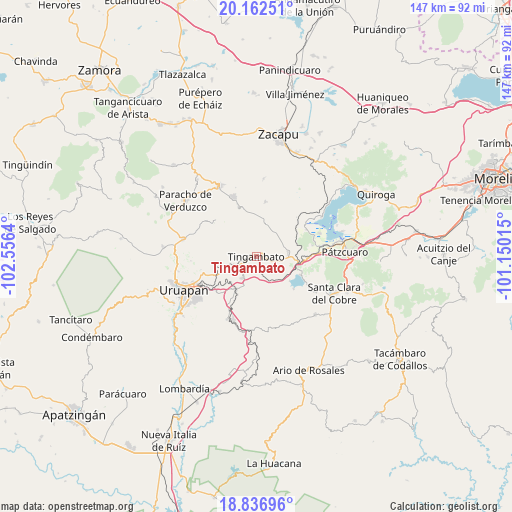
Tingambato GPS coordinates[2]
19° 30' 3.924" North, 101° 51' 11.772" West
| Map corner | latitude | longitude |
|---|---|---|
| Upper-left | 20.16251°, | -102.5564° |
| Center: | 19.50109°, | -101.85327° |
| Lower-right: | 18.83696°, | -101.15015° |
| Map W x H: | 147.4×147.4 km | = 91.6×91.6mi |
| max Lat: | 32.7° ⇑54% North |
| Tingambato: | 19.50109° |
| min Lat: | ⇓46% South 14.53588° |
| min Long | Tingambato | max Long |
| -117.105° | -101.85327° | -86.73105° |
| W 20%⇐ | ⇒80% E |
Elevation
Elevation of Tingambato is 1978 m = 6490 ft, and this is 724.3 m = 2376 ft above average elevation for this country.
| Max E: |
3497 m = 11473 ft | 27.5% |
| Tingambato | 1978 m 6490 ft | |
| Avg. | 1253.7 m = 4113 ft | |
Min E: |
-1 m = -3 ft | 72.5% |
See also: Mexico elevation on elevation.city.
Geographical zone
Tingambato is located in North Torrid zone (between Equator and Tropic of Cancer). Distance of this Northern Tropic circle is 437.6 km =271.9 mi to North.| Distance of | km | miles | from Tingambato |
|---|---|---|---|
| North Pole | 7838.7 | 4870.7 | to North |
| Arctic Circle | 5232.9 | 3251.6 | to North |
| Tropic Cancer | 437.6 | 271.9 | to North |
| Equator | 2168.3 | 1347.3 | to South |


Nearby cities:
15 places around Tingambato: (largest is in red/bold)
• Ajuno
13.7 km =8.5 mi,  84°
84°
• Arantepacua
16 km =9.9 mi,  311°
311°
• Caracha
10.3 km =6.4 mi,  224°
224°
• Comachuén
9.5 km =5.9 mi,  325°
325°
• La Escondida
3.6 km =2.2 mi,  178°
178°
• Patuán
13.8 km =8.6 mi,  208°
208°
• Pichátaro
9.3 km =5.8 mi,  31°
31°
• San Andrés Coru
10.3 km =6.4 mi,  248°
248°
• San Isidro
15.9 km =9.9 mi,  9°
9°
• Santa María Huiramangaro (San Juan Tumbio)
9.3 km =5.8 mi, 81°
• Sevina
15.1 km =9.4 mi,  340°
340°
• Turícuaro
11.7 km =7.3 mi, 311°
• Uricho
16.3 km =10.1 mi,  61°
61°
• Zirahuén
13.8 km =8.6 mi,  112°
112°
• Zirimícuaro
15.1 km =9.4 mi,  226°
226°
Sources, notices
• [Note1] Compared only with cities in Mexico existing in our database
• [Src1] Map data: © OpenStreetMap contributors (CC-BY-SA)
• [Src2] Other city data from geonames.org with taken over terms of usage.
• [Src3] Geographical zone / Annual Mean Temperature by Robert A. Rohde @ Wikipedia
