Ixteamel geodata
Ixteamel (San Luis Potosí) is a populated place; located in Mexico in America/Mexico_City (GMT-6) time zone. With population of 925 people, there are 9432 cities with bigger population in this country. Compared to other cities in Mexico, 79.9% of cities are located further ↓South; 53.7% of cities are located further ←West and 74.3% of cities have higher elevation than Ixteamel. Note1


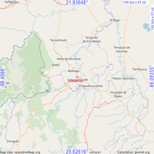
Ixteamel GPS coordinates[2]
21° 16' 58.008" North, 98° 47' 48.012" West
| Map corner | latitude | longitude |
|---|---|---|
| Upper-left | 21.93648°, | -99.4998° |
| Center: | 21.28278°, | -98.79667° |
| Lower-right: | 20.62616°, | -98.09355° |
| Map W x H: | 145.7×145.7 km | = 90.5×90.5mi |
| max Lat: | 32.7° ⇑20.1% North |
| Ixteamel: | 21.28278° |
| min Lat: | ⇓79.9% South 14.53588° |
| min Long | Ixteamel | max Long |
| -117.105° | -98.79667° | -86.73105° |
| W 53.7%⇐ | ⇒46.3% E |
Elevation
Elevation of Ixteamel is 244 m = 801 ft, and this is 1009.7 m = 3313 ft below average elevation for this country.
| Max E: |
3497 m = 11473 ft | 74.3% |
| Avg. | 1253.7 m = 4113 ft | |
| Ixteamel | 244 m = 801 ft | |
Min E: |
-1 m = -3 ft | 25.7% |
See also: Mexico elevation on elevation.city.
Geographical zone
Ixteamel is located in North Torrid zone (between Equator and Tropic of Cancer). Distance of this Northern Tropic circle is 239.5 km =148.8 mi to North.| Distance of | km | miles | from Ixteamel |
|---|---|---|---|
| North Pole | 7640.6 | 4747.6 | to North |
| Arctic Circle | 5034.8 | 3128.5 | to North |
| Tropic Cancer | 239.5 | 148.8 | to North |
| Equator | 2366.4 | 1470.4 | to South |


Nearby cities:
15 places around Ixteamel: (largest is in red/bold)
• Ahuehueyo
1.5 km =0.9 mi,  281°
281°
• Atlamaxátl
4.3 km =2.7 mi,  316°
316°
• Chalchocoyo
3.6 km =2.2 mi,  7°
7°
• Cuixcuatitla
3.5 km =2.2 mi,  59°
59°
• El Piñal
6 km =3.7 mi,  125°
125°
• El Tepetate
5.2 km =3.2 mi,  77°
77°
• Ixtlapalaco
3.3 km =2.1 mi,  118°
118°
• Nexcuayo II
4.8 km =3 mi,  1°
1°
• Tacial
3.3 km =2.1 mi,  205°
205°
• Tamacol
6.1 km =3.8 mi, 208°
• Tamazunchale
2.7 km =1.7 mi,  163°
163°
• Tepetzintla
3.5 km =2.2 mi,  314°
314°
• Texquitote Primero
1.7 km =1.1 mi,  344°
344°
• Vega Larga
5.3 km =3.3 mi,  236°
236°
• Xochititla
3.5 km =2.2 mi, 337°
Sources, notices
• [Note1] Compared only with cities in Mexico existing in our database
• [Src1] Map data: © OpenStreetMap contributors (CC-BY-SA)
• [Src2] Other city data from geonames.org with taken over terms of usage.
• [Src3] Geographical zone / Annual Mean Temperature by Robert A. Rohde @ Wikipedia
