Tamazunchale geodata
Tamazunchale (San Luis Potosí) is a seat of a second-order administrative division; located in Mexico in America/Mexico_City (GMT-6) time zone. With population of 24,562 people, there are 412 cities with bigger population in this country. Compared to other cities in Mexico, 79.7% of cities are located further ↓South; 53.8% of cities are located further ←West and 78% of cities have higher elevation than Tamazunchale. Note1


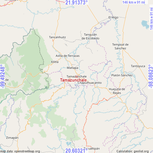
Tamazunchale GPS coordinates[2]
21° 15' 35.748" North, 98° 47' 21.66" West
| Map corner | latitude | longitude |
|---|---|---|
| Upper-left | 21.91373°, | -99.49248° |
| Center: | 21.25993°, | -98.78935° |
| Lower-right: | 20.60321°, | -98.08623° |
| Map W x H: | 145.7×145.7 km | = 90.5×90.5mi |
| max Lat: | 32.7° ⇑20.3% North |
| Tamazunchale: | 21.25993° |
| min Lat: | ⇓79.7% South 14.53588° |
| min Long | Tamazunchale | max Long |
| -117.105° | -98.78935° | -86.73105° |
| W 53.8%⇐ | ⇒46.2% E |
Elevation
Elevation of Tamazunchale is 131 m = 430 ft, and this is 1122.7 m = 3683 ft below average elevation for this country.
| Max E: |
3497 m = 11473 ft | 78% |
| Avg. | 1253.7 m = 4113 ft | |
| Tamazunchale | 131 m = 430 ft | |
Min E: |
-1 m = -3 ft | 22% |
See also: Mexico elevation on elevation.city.
Geographical zone
Tamazunchale is located in North Torrid zone (between Equator and Tropic of Cancer). Distance of this Northern Tropic circle is 242 km =150.4 mi to North.| Distance of | km | miles | from Tamazunchale |
|---|---|---|---|
| North Pole | 7643.2 | 4749.3 | to North |
| Arctic Circle | 5037.3 | 3130 | to North |
| Tropic Cancer | 242 | 150.4 | to North |
| Equator | 2363.9 | 1468.9 | to South |


Nearby cities:
15 places around Tamazunchale: (largest is in red/bold)
• Ahuehueyo
3.6 km =2.2 mi,  321°
321°
• Atlajque
5.3 km =3.3 mi,  196°
196°
• Coaxocotitla
5.8 km =3.6 mi,  162°
162°
• Cuixcuatitla
4.9 km =3 mi,  27°
27°
• El Piñal
4.2 km =2.6 mi,  103°
103°
• El Tepetate
5.7 km =3.5 mi,  49°
49°
• Ixteamel
2.7 km =1.7 mi,  343°
343°
• Ixtlapalaco
2.4 km =1.5 mi,  66°
66°
• Mecatlán
4.5 km =2.8 mi,  184°
184°
• Tacial
2.2 km =1.4 mi,  259°
259°
• Tamacol
4.6 km =2.9 mi,  232°
232°
• Temamatla
4 km =2.5 mi,  134°
134°
• Tepetzintla
6 km =3.7 mi,  327°
327°
• Texquitote Primero
4.4 km =2.7 mi, 343°
• Vega Larga
5.2 km =3.2 mi,  265°
265°
Sources, notices
• [Note1] Compared only with cities in Mexico existing in our database
• [Src1] Map data: © OpenStreetMap contributors (CC-BY-SA)
• [Src2] Other city data from geonames.org with taken over terms of usage.
• [Src3] Geographical zone / Annual Mean Temperature by Robert A. Rohde @ Wikipedia
