Cuixcuatitla geodata
Cuixcuatitla (San Luis Potosí) is a populated place; located in Mexico in America/Mexico_City (GMT-6) time zone. With population of 705 people, there are 12337 cities with bigger population in this country. Compared to other cities in Mexico, 80% of cities are located further ↓South; 54.1% of cities are located further ←West and 78.4% of cities have higher elevation than Cuixcuatitla. Note1


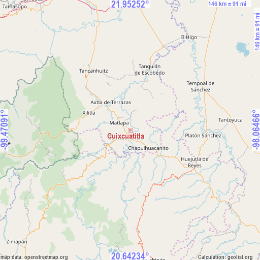
Cuixcuatitla GPS coordinates[2]
21° 17' 56.004" North, 98° 46' 4.008" West
| Map corner | latitude | longitude |
|---|---|---|
| Upper-left | 21.95252°, | -99.47091° |
| Center: | 21.29889°, | -98.76778° |
| Lower-right: | 20.64234°, | -98.06466° |
| Map W x H: | 145.7×145.7 km | = 90.5×90.5mi |
| max Lat: | 32.7° ⇑20% North |
| Cuixcuatitla: | 21.29889° |
| min Lat: | ⇓80% South 14.53588° |
| min Long | Cuixcuatitla | max Long |
| -117.105° | -98.76778° | -86.73105° |
| W 54.1%⇐ | ⇒45.9% E |
Elevation
Elevation of Cuixcuatitla is 123 m = 404 ft, and this is 1130.7 m = 3710 ft below average elevation for this country.
| Max E: |
3497 m = 11473 ft | 78.4% |
| Avg. | 1253.7 m = 4113 ft | |
| Cuixcuatitla | 123 m = 404 ft | |
Min E: |
-1 m = -3 ft | 21.6% |
See also: Mexico elevation on elevation.city.
Geographical zone
Cuixcuatitla is located in North Torrid zone (between Equator and Tropic of Cancer). Distance of this Northern Tropic circle is 237.7 km =147.7 mi to North.| Distance of | km | miles | from Cuixcuatitla |
|---|---|---|---|
| North Pole | 7638.8 | 4746.5 | to North |
| Arctic Circle | 5033 | 3127.4 | to North |
| Tropic Cancer | 237.7 | 147.7 | to North |
| Equator | 2368.2 | 1471.5 | to South |


Nearby cities:
15 places around Cuixcuatitla: (largest is in red/bold)
• Ahuehueyo
4.7 km =2.9 mi,  251°
251°
• Atlamaxátl
6.1 km =3.8 mi,  282°
282°
• Chalchocoyo
3 km =1.9 mi,  304°
304°
• El Huexco
4.9 km =3 mi,  17°
17°
• El Piñal
5.6 km =3.5 mi,  160°
160°
• El Tepetate
2.2 km =1.4 mi,  106°
106°
• Ixteamel
3.5 km =2.2 mi,  239°
239°
• Ixtlapalaco
3.4 km =2.1 mi,  180°
180°
• La Cichilla
4.7 km =2.9 mi, 107°
• Nexcuayo II
4.2 km =2.6 mi,  315°
315°
• Ocuiltzapoyo
5 km =3.1 mi,  55°
55°
• Tamazunchale
4.9 km =3 mi,  207°
207°
• Tepetzintla
5.5 km =3.4 mi, 277°
• Texquitote Primero
3.5 km =2.2 mi,  267°
267°
• Xochititla
4.6 km =2.9 mi,  288°
288°
Sources, notices
• [Note1] Compared only with cities in Mexico existing in our database
• [Src1] Map data: © OpenStreetMap contributors (CC-BY-SA)
• [Src2] Other city data from geonames.org with taken over terms of usage.
• [Src3] Geographical zone / Annual Mean Temperature by Robert A. Rohde @ Wikipedia
