El Tepetate geodata
El Tepetate (San Luis Potosí) is a populated place; located in Mexico in America/Mexico_City (GMT-6) time zone. With population of 525 people, there are 16085 cities with bigger population in this country. Compared to other cities in Mexico, 80% of cities are located further ↓South; 54.4% of cities are located further ←West and 78.9% of cities have higher elevation than El Tepetate. Note1


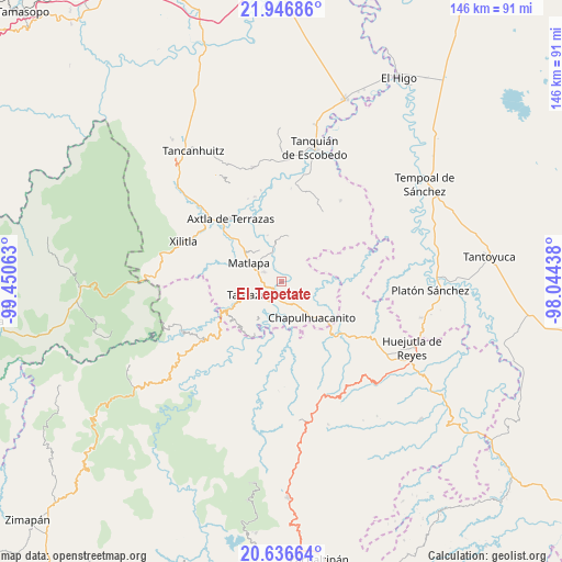
El Tepetate GPS coordinates[2]
21° 17' 35.556" North, 98° 44' 51" West
| Map corner | latitude | longitude |
|---|---|---|
| Upper-left | 21.94686°, | -99.45063° |
| Center: | 21.29321°, | -98.7475° |
| Lower-right: | 20.63664°, | -98.04438° |
| Map W x H: | 145.7×145.7 km | = 90.5×90.5mi |
| max Lat: | 32.7° ⇑20% North |
| El Tepetate: | 21.29321° |
| min Lat: | ⇓80% South 14.53588° |
| min Long | El Tepetate | max Long |
| -117.105° | -98.7475° | -86.73105° |
| W 54.4%⇐ | ⇒45.6% E |
Elevation
Elevation of El Tepetate is 113 m = 371 ft, and this is 1140.7 m = 3742 ft below average elevation for this country.
| Max E: |
3497 m = 11473 ft | 78.9% |
| Avg. | 1253.7 m = 4113 ft | |
| El Tepetate | 113 m = 371 ft | |
Min E: |
-1 m = -3 ft | 21.1% |
See also: Mexico elevation on elevation.city.
Geographical zone
El Tepetate is located in North Torrid zone (between Equator and Tropic of Cancer). Distance of this Northern Tropic circle is 238.3 km =148.1 mi to North.| Distance of | km | miles | from El Tepetate |
|---|---|---|---|
| North Pole | 7639.5 | 4747 | to North |
| Arctic Circle | 5033.6 | 3127.7 | to North |
| Tropic Cancer | 238.3 | 148.1 | to North |
| Equator | 2367.6 | 1471.2 | to South |


Nearby cities:
15 places around El Tepetate: (largest is in red/bold)
• Ahuehueyo
6.6 km =4.1 mi,  262°
262°
• Chalchocoyo
5.2 km =3.2 mi,  297°
297°
• Cuixcuatitla
2.2 km =1.4 mi,  286°
286°
• El Huexco
5.3 km =3.3 mi,  353°
353°
• El Palmito
6.3 km =3.9 mi,  140°
140°
• El Piñal
4.7 km =2.9 mi,  182°
182°
• Escoatitla
6.5 km =4 mi,  45°
45°
• Ixteamel
5.2 km =3.2 mi, 257°
• Ixtlapalaco
3.5 km =2.2 mi,  217°
217°
• La Cichilla
2.5 km =1.6 mi,  108°
108°
• Nexcuayo II
6.2 km =3.9 mi,  305°
305°
• Ocuiltzapoyo
4 km =2.5 mi,  29°
29°
• Tamazunchale
5.7 km =3.5 mi,  229°
229°
• Temamatla
6.7 km =4.2 mi,  192°
192°
• Texquitote Primero
5.6 km =3.5 mi,  275°
275°
Sources, notices
• [Note1] Compared only with cities in Mexico existing in our database
• [Src1] Map data: © OpenStreetMap contributors (CC-BY-SA)
• [Src2] Other city data from geonames.org with taken over terms of usage.
• [Src3] Geographical zone / Annual Mean Temperature by Robert A. Rohde @ Wikipedia
