Bachajón geodata
Bachajón (Chiapas) is a populated place; located in Mexico in America/Mexico_City (GMT-6) time zone. With population of 5,063 people, there are 1829 cities with bigger population in this country. Compared to other cities in Mexico, 88.3% of cities are located further ↑North; 94.2% of cities are located further ←West and 61.4% of cities have higher elevation than Bachajón. Note1


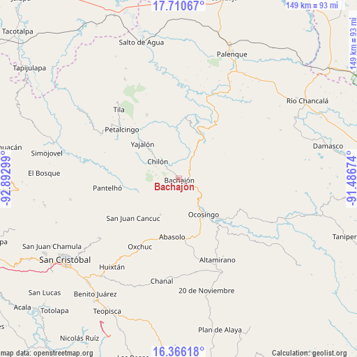
Bachajón GPS coordinates[2]
17° 2' 22.668" North, 92° 11' 23.496" West
| Map corner | latitude | longitude |
|---|---|---|
| Upper-left | 17.71067°, | -92.89299° |
| Center: | 17.03963°, | -92.18986° |
| Lower-right: | 16.36618°, | -91.48674° |
| Map W x H: | 149.5×149.5 km | = 92.9×92.9mi |
| max Lat: | 32.7° ⇑88.3% North |
| Bachajón: | 17.03963° |
| min Lat: | ⇓11.7% South 14.53588° |
| min Long | Bachajón | max Long |
| -117.105° | -92.18986° | -86.73105° |
| W 94.2%⇐ | ⇒5.8% E |
Elevation
Elevation of Bachajón is 915 m = 3002 ft, and this is 338.7 m = 1111 ft below average elevation for this country.
| Max E: |
3497 m = 11473 ft | 61.4% |
| Avg. | 1253.7 m = 4113 ft | |
| Bachajón | 915 m = 3002 ft | |
Min E: |
-1 m = -3 ft | 38.6% |
See also: Mexico elevation on elevation.city.
Geographical zone
Bachajón is located in North Torrid zone (between Equator and Tropic of Cancer). Distance of this Northern Tropic circle is 711.3 km =442 mi to North.| Distance of | km | miles | from Bachajón |
|---|---|---|---|
| North Pole | 8112.4 | 5040.8 | to North |
| Arctic Circle | 5506.5 | 3421.6 | to North |
| Tropic Cancer | 711.3 | 442 | to North |
| Equator | 1894.6 | 1177.2 | to South |


Nearby cities:
15 places around Bachajón: (largest is in red/bold)
• Chilón
11.5 km =7.1 mi,  309°
309°
• Corostic
10.2 km =6.3 mi,  18°
18°
• Guaquitepec
12.3 km =7.6 mi,  237°
237°
• Joybé
4.5 km =2.8 mi,  121°
121°
• Juan Sabines Verapaz
13.6 km =8.5 mi,  287°
287°
• Mequeja
10.3 km =6.4 mi,  208°
208°
• Patatehel
14.9 km =9.3 mi,  9°
9°
• Patria Nueva (San José el Contento)
14.8 km =9.2 mi,  146°
146°
• San Antonio Bulujib
12.3 km =7.6 mi,  247°
247°
• San Marcos
9.4 km =5.8 mi,  194°
194°
• Santa Cruz la Reforma
11.5 km =7.1 mi,  277°
277°
• Sibacá
13.2 km =8.2 mi,  156°
156°
• Sitalá
12.6 km =7.8 mi,  262°
262°
• Tzobojitle Jotoaquil
13.8 km =8.6 mi,  104°
104°
• Xaxajatic
12.8 km =8 mi, 16°
Sources, notices
• [Note1] Compared only with cities in Mexico existing in our database
• [Src1] Map data: © OpenStreetMap contributors (CC-BY-SA)
• [Src2] Other city data from geonames.org with taken over terms of usage.
• [Src3] Geographical zone / Annual Mean Temperature by Robert A. Rohde @ Wikipedia
