Ahuatempa geodata
Ahuatempa (Hidalgo) is a populated place; located in Mexico in America/Mexico_City (GMT-6) time zone. With population of 907 people, there are 9625 cities with bigger population in this country. Compared to other cities in Mexico, 77.8% of cities are located further ↓South; 58.9% of cities are located further ←West and 76.6% of cities have higher elevation than Ahuatempa. Note1


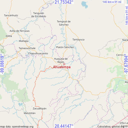
Ahuatempa GPS coordinates[2]
21° 5' 56.004" North, 98° 22' 59.016" West
| Map corner | latitude | longitude |
|---|---|---|
| Upper-left | 21.75342°, | -99.08619° |
| Center: | 21.09889°, | -98.38306° |
| Lower-right: | 20.44147°, | -97.67994° |
| Map W x H: | 145.9×145.9 km | = 90.7×90.7mi |
| max Lat: | 32.7° ⇑22.2% North |
| Ahuatempa: | 21.09889° |
| min Lat: | ⇓77.8% South 14.53588° |
| min Long | Ahuatempa | max Long |
| -117.105° | -98.38306° | -86.73105° |
| W 58.9%⇐ | ⇒41.1% E |
Elevation
Elevation of Ahuatempa is 164 m = 538 ft, and this is 1089.7 m = 3575 ft below average elevation for this country.
| Max E: |
3497 m = 11473 ft | 76.6% |
| Avg. | 1253.7 m = 4113 ft | |
| Ahuatempa | 164 m = 538 ft | |
Min E: |
-1 m = -3 ft | 23.4% |
See also: Mexico elevation on elevation.city.
Geographical zone
Ahuatempa is located in North Torrid zone (between Equator and Tropic of Cancer). Distance of this Northern Tropic circle is 259.9 km =161.5 mi to North.| Distance of | km | miles | from Ahuatempa |
|---|---|---|---|
| North Pole | 7661.1 | 4760.4 | to North |
| Arctic Circle | 5055.2 | 3141.2 | to North |
| Tropic Cancer | 259.9 | 161.5 | to North |
| Equator | 2346 | 1457.7 | to South |


Nearby cities:
15 places around Ahuatempa: (largest is in red/bold)
• Aguacatitla
6.9 km =4.3 mi,  283°
283°
• Atalco
6.2 km =3.9 mi,  261°
261°
• Chalahuiyapa
6.1 km =3.8 mi,  18°
18°
• Chililico
6.7 km =4.2 mi,  305°
305°
• Corral Blanco (Todos por Hidalgo)
6.1 km =3.8 mi,  354°
354°
• Huejutla de Reyes
5.9 km =3.7 mi,  320°
320°
• Huitzotlaco
6.6 km =4.1 mi,  174°
174°
• La Candelaria
2.7 km =1.7 mi,  234°
234°
• La Mesa de Limatitla
4.7 km =2.9 mi,  235°
235°
• Las Pilas
7 km =4.3 mi,  341°
341°
• Los Otates
6.9 km =4.3 mi,  33°
33°
• Parque de Poblamiento Solidaridad
5.9 km =3.7 mi,  356°
356°
• Santa Catarina
0.3 km =0.2 mi,  53°
53°
• Tenexco II
5 km =3.1 mi,  138°
138°
• Xiquila
6.7 km =4.2 mi,  249°
249°
Sources, notices
• [Note1] Compared only with cities in Mexico existing in our database
• [Src1] Map data: © OpenStreetMap contributors (CC-BY-SA)
• [Src2] Other city data from geonames.org with taken over terms of usage.
• [Src3] Geographical zone / Annual Mean Temperature by Robert A. Rohde @ Wikipedia
