Fresnal geodata
Fresnal (Veracruz) is a populated place; located in Mexico in America/Mexico_City (GMT-6) time zone. With population of 850 people, there are 10289 cities with bigger population in this country. Compared to other cities in Mexico, 68.4% of cities are located further ↑North; 75.1% of cities are located further ←West and 63.4% of cities have higher elevation than Fresnal. Note1


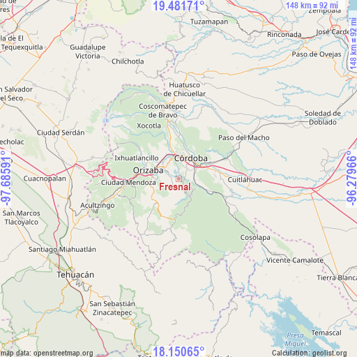
Fresnal GPS coordinates[2]
18° 49' 3" North, 96° 58' 58.008" West
| Map corner | latitude | longitude |
|---|---|---|
| Upper-left | 19.48171°, | -97.68591° |
| Center: | 18.8175°, | -96.98278° |
| Lower-right: | 18.15065°, | -96.27966° |
| Map W x H: | 148×148 km | = 92×92mi |
| max Lat: | 32.7° ⇑68.4% North |
| Fresnal: | 18.8175° |
| min Lat: | ⇓31.6% South 14.53588° |
| min Long | Fresnal | max Long |
| -117.105° | -96.98278° | -86.73105° |
| W 75.1%⇐ | ⇒24.9% E |
Elevation
Elevation of Fresnal is 793 m = 2602 ft, and this is 460.7 m = 1511 ft below average elevation for this country.
| Max E: |
3497 m = 11473 ft | 63.4% |
| Avg. | 1253.7 m = 4113 ft | |
| Fresnal | 793 m = 2602 ft | |
Min E: |
-1 m = -3 ft | 36.6% |
See also: Mexico elevation on elevation.city.
Geographical zone
Fresnal is located in North Torrid zone (between Equator and Tropic of Cancer). Distance of this Northern Tropic circle is 513.6 km =319.1 mi to North.| Distance of | km | miles | from Fresnal |
|---|---|---|---|
| North Pole | 7914.8 | 4918 | to North |
| Arctic Circle | 5308.9 | 3298.8 | to North |
| Tropic Cancer | 513.6 | 319.1 | to North |
| Equator | 2092.3 | 1300.1 | to South |


Nearby cities:
15 places around Fresnal: (largest is in red/bold)
• Campo Chico
5.2 km =3.2 mi,  293°
293°
• Campo Grande
3.2 km =2 mi,  280°
280°
• Capoluca
4.8 km =3 mi,  255°
255°
• Centro de Readaptación Social
5.1 km =3.2 mi,  63°
63°
• Cuesta del Mexicano
1.6 km =1 mi,  207°
207°
• El Campanario
5.8 km =3.6 mi,  173°
173°
• Naranjal
2.2 km =1.4 mi,  109°
109°
• Rincón de Maravillas
4 km =2.5 mi,  202°
202°
• San José de Tapia
4.5 km =2.8 mi,  42°
42°
• Trapiche Viejo
4.8 km =3 mi,  54°
54°
• Tuxpanguillo
5 km =3.1 mi,  218°
218°
• Veinte de Noviembre
6.1 km =3.8 mi,  29°
29°
• Villa Libertad
2.8 km =1.7 mi,  97°
97°
• Villa Unión
4.1 km =2.5 mi,  0°
0°
• Zapoapan
2.7 km =1.7 mi,  336°
336°
Sources, notices
• [Note1] Compared only with cities in Mexico existing in our database
• [Src1] Map data: © OpenStreetMap contributors (CC-BY-SA)
• [Src2] Other city data from geonames.org with taken over terms of usage.
• [Src3] Geographical zone / Annual Mean Temperature by Robert A. Rohde @ Wikipedia
