Trapiche Viejo geodata
Trapiche Viejo (Veracruz) is a populated place; located in Mexico in America/Mexico_City (GMT-6) time zone. With population of 1,112 people, there are 7813 cities with bigger population in this country. Compared to other cities in Mexico, 68% of cities are located further ↑North; 75.6% of cities are located further ←West and 63.4% of cities have higher elevation than Trapiche Viejo. Note1


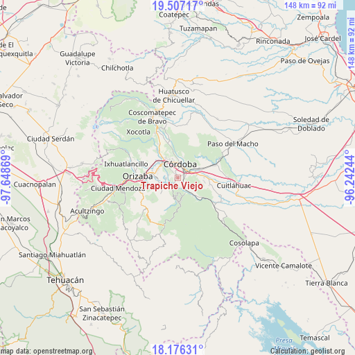
Trapiche Viejo GPS coordinates[2]
18° 50' 35.016" North, 96° 56' 44.016" West
| Map corner | latitude | longitude |
|---|---|---|
| Upper-left | 19.50717°, | -97.64869° |
| Center: | 18.84306°, | -96.94556° |
| Lower-right: | 18.17631°, | -96.24244° |
| Map W x H: | 148×148 km | = 92×92mi |
| max Lat: | 32.7° ⇑68% North |
| Trapiche Viejo: | 18.84306° |
| min Lat: | ⇓32% South 14.53588° |
| min Long | Trapiche Viejo | max Long |
| -117.105° | -96.94556° | -86.73105° |
| W 75.6%⇐ | ⇒24.4% E |
Elevation
Elevation of Trapiche Viejo is 790 m = 2592 ft, and this is 463.7 m = 1521 ft below average elevation for this country.
| Max E: |
3497 m = 11473 ft | 63.4% |
| Avg. | 1253.7 m = 4113 ft | |
| Trapiche Viejo | 790 m = 2592 ft | |
Min E: |
-1 m = -3 ft | 36.6% |
See also: Mexico elevation on elevation.city.
Geographical zone
Trapiche Viejo is located in North Torrid zone (between Equator and Tropic of Cancer). Distance of this Northern Tropic circle is 510.8 km =317.4 mi to North.| Distance of | km | miles | from Trapiche Viejo |
|---|---|---|---|
| North Pole | 7911.9 | 4916.2 | to North |
| Arctic Circle | 5306 | 3297 | to North |
| Tropic Cancer | 510.8 | 317.4 | to North |
| Equator | 2095.2 | 1301.9 | to South |


Nearby cities:
15 places around Trapiche Viejo: (largest is in red/bold)
• Agustín Millán
5.5 km =3.4 mi,  29°
29°
• Amatlán de los Reyes
3.1 km =1.9 mi,  82°
82°
• Centro de Readaptación Social
0.9 km =0.6 mi,  130°
130°
• Córdoba
5 km =3.1 mi,  24°
24°
• El Pueblito
5.4 km =3.4 mi,  332°
332°
• Fredepo
5.3 km =3.3 mi,  321°
321°
• Fresnal
4.8 km =3 mi,  234°
234°
• Guadalupe
3.8 km =2.4 mi,  143°
143°
• Naranjal
4 km =2.5 mi,  206°
206°
• San José de Tapia
1 km =0.6 mi,  297°
297°
• Veinte de Noviembre
2.6 km =1.6 mi,  338°
338°
• Villa Libertad
3.4 km =2.1 mi,  200°
200°
• Villa Unión
4.1 km =2.5 mi,  287°
287°
• Zacatepec
3.4 km =2.1 mi,  353°
353°
• Zapoapan
5 km =3.1 mi,  266°
266°
Sources, notices
• [Note1] Compared only with cities in Mexico existing in our database
• [Src1] Map data: © OpenStreetMap contributors (CC-BY-SA)
• [Src2] Other city data from geonames.org with taken over terms of usage.
• [Src3] Geographical zone / Annual Mean Temperature by Robert A. Rohde @ Wikipedia
