Las Cañadas geodata
Las Cañadas (Michoacán) is a populated place; located in Mexico in America/Mexico_City (GMT-6) time zone. With population of 2,223 people, there are 3947 cities with bigger population in this country. Compared to other cities in Mexico, 63.5% of cities are located further ↓South; 80.8% of cities are located further →East and 59.6% of cities have lower elevation than Las Cañadas. Note1


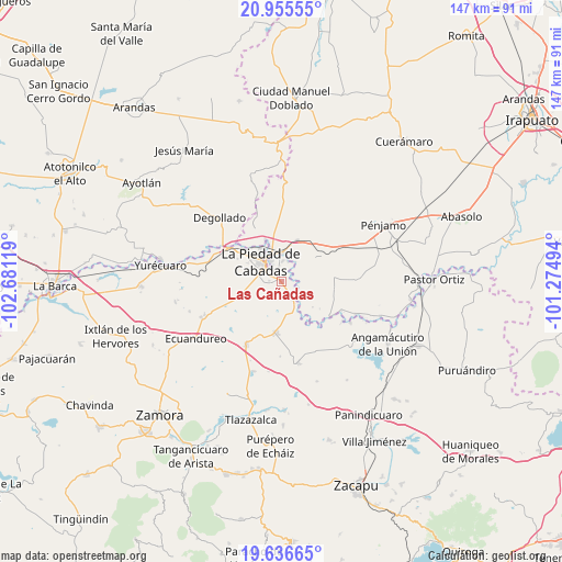
Las Cañadas GPS coordinates[2]
20° 17' 51" North, 101° 58' 41.016" West
| Map corner | latitude | longitude |
|---|---|---|
| Upper-left | 20.95555°, | -102.68119° |
| Center: | 20.2975°, | -101.97806° |
| Lower-right: | 19.63665°, | -101.27494° |
| Map W x H: | 146.6×146.7 km | = 91.1×91.2mi |
| max Lat: | 32.7° ⇑36.5% North |
| Las Cañadas: | 20.2975° |
| min Lat: | ⇓63.5% South 14.53588° |
| min Long | Las Cañadas | max Long |
| -117.105° | -101.97806° | -86.73105° |
| W 19.2%⇐ | ⇒80.8% E |
Elevation
Elevation of Las Cañadas is 1719 m = 5640 ft, and this is 465.3 m = 1527 ft above average elevation for this country.
| Max E: |
3497 m = 11473 ft | 40.4% |
| Las Cañadas | 1719 m 5640 ft | |
| Avg. | 1253.7 m = 4113 ft | |
Min E: |
-1 m = -3 ft | 59.6% |
See also: Mexico elevation on elevation.city.
Geographical zone
Las Cañadas is located in North Torrid zone (between Equator and Tropic of Cancer). Distance of this Northern Tropic circle is 349 km =216.9 mi to North.| Distance of | km | miles | from Las Cañadas |
|---|---|---|---|
| North Pole | 7750.2 | 4815.7 | to North |
| Arctic Circle | 5144.3 | 3196.5 | to North |
| Tropic Cancer | 349 | 216.9 | to North |
| Equator | 2256.9 | 1402.4 | to South |


Nearby cities:
15 places around Las Cañadas: (largest is in red/bold)
• Cañada de Ramírez
1.5 km =0.9 mi,  94°
94°
• Estación la Piedad
8.1 km =5 mi,  345°
345°
• Guanajuatillo
4.8 km =3 mi,  333°
333°
• Guayabito de Pedroza
8.8 km =5.5 mi,  6°
6°
• La Cal Grande
6.3 km =3.9 mi,  34°
34°
• La Estancia del Refugio
4.8 km =3 mi, 91°
• La Lobera
7.3 km =4.5 mi,  101°
101°
• La Piedad
7.4 km =4.6 mi,  312°
312°
• Lagunillas
8.5 km =5.3 mi,  78°
78°
• Mezquite de Luna
8.9 km =5.5 mi, 89°
• Numarán
5.5 km =3.4 mi,  147°
147°
• Río Grande
5.9 km =3.7 mi, 331°
• Santa Ana Pacueco
6.8 km =4.2 mi,  324°
324°
• Villas de las Lomas
1.2 km =0.7 mi,  274°
274°
• Zaragoza
5.4 km =3.4 mi,  16°
16°
Sources, notices
• [Note1] Compared only with cities in Mexico existing in our database
• [Src1] Map data: © OpenStreetMap contributors (CC-BY-SA)
• [Src2] Other city data from geonames.org with taken over terms of usage.
• [Src3] Geographical zone / Annual Mean Temperature by Robert A. Rohde @ Wikipedia
