La Lobera geodata
La Lobera (Michoacán) is a populated place; located in Mexico in America/Mexico_City (GMT-6) time zone. With population of 634 people, there are 13664 cities with bigger population in this country. Compared to other cities in Mexico, 57.9% of cities are located further ↓South; 73.9% of cities are located further →East and 65.4% of cities have lower elevation than La Lobera. Note1


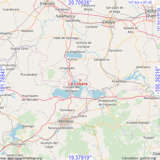
La Lobera GPS coordinates[2]
20° 2' 27.996" North, 101° 3' 55.008" West
| Map corner | latitude | longitude |
|---|---|---|
| Upper-left | 20.70026°, | -101.76841° |
| Center: | 20.04111°, | -101.06528° |
| Lower-right: | 19.37919°, | -100.36216° |
| Map W x H: | 146.9×146.9 km | = 91.3×91.3mi |
| max Lat: | 32.7° ⇑42.1% North |
| La Lobera: | 20.04111° |
| min Lat: | ⇓57.9% South 14.53588° |
| min Long | La Lobera | max Long |
| -117.105° | -101.06528° | -86.73105° |
| W 26.1%⇐ | ⇒73.9% E |
Elevation
Elevation of La Lobera is 1839 m = 6033 ft, and this is 585.3 m = 1920 ft above average elevation for this country.
| Max E: |
3497 m = 11473 ft | 34.6% |
| La Lobera | 1839 m 6033 ft | |
| Avg. | 1253.7 m = 4113 ft | |
Min E: |
-1 m = -3 ft | 65.4% |
See also: Mexico elevation on elevation.city.
Geographical zone
La Lobera is located in North Torrid zone (between Equator and Tropic of Cancer). Distance of this Northern Tropic circle is 377.6 km =234.6 mi to North.| Distance of | km | miles | from La Lobera |
|---|---|---|---|
| North Pole | 7778.7 | 4833.5 | to North |
| Arctic Circle | 5172.8 | 3214.2 | to North |
| Tropic Cancer | 377.6 | 234.6 | to North |
| Equator | 2228.4 | 1384.7 | to South |


Nearby cities:
15 places around La Lobera: (largest is in red/bold)
• Chupícuaro
11.7 km =7.3 mi,  249°
249°
• Cuamio
9.1 km =5.7 mi,  264°
264°
• Cuaracurío
8.9 km =5.5 mi,  284°
284°
• Cuitzeo del Porvenir
11.3 km =7 mi,  225°
225°
• El Derramadero
8 km =5 mi,  303°
303°
• El Salteador
11 km =6.8 mi,  353°
353°
• El Timbinal
6.1 km =3.8 mi,  16°
16°
• Huacao
4.4 km =2.7 mi,  86°
86°
• La Ortiga
11.1 km =6.9 mi,  142°
142°
• Las Cruces
11.3 km =7 mi,  54°
54°
• Mariano Escobedo
8.5 km =5.3 mi,  177°
177°
• San Agustín del Pulque
8.8 km =5.5 mi,  185°
185°
• San José Cuaracurio
11.9 km =7.4 mi,  305°
305°
• San Rafael del Carrizal
3.6 km =2.2 mi, 311°
• Santa Ana Maya
5.9 km =3.7 mi,  130°
130°
Sources, notices
• [Note1] Compared only with cities in Mexico existing in our database
• [Src1] Map data: © OpenStreetMap contributors (CC-BY-SA)
• [Src2] Other city data from geonames.org with taken over terms of usage.
• [Src3] Geographical zone / Annual Mean Temperature by Robert A. Rohde @ Wikipedia
