Veinticuatro geodata
Veinticuatro (Veracruz) is a populated place; located in Mexico in America/Mexico_City (GMT-6) time zone. With population of 582 people, there are 14734 cities with bigger population in this country. Compared to other cities in Mexico, 86% of cities are located further ↑North; 85% of cities are located further ←West and 79.8% of cities have higher elevation than Veinticuatro. Note1


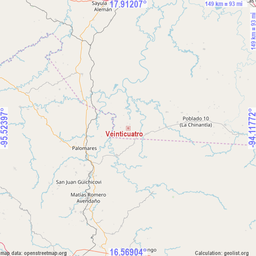
Veinticuatro GPS coordinates[2]
17° 14' 30.408" North, 94° 49' 15.024" West
| Map corner | latitude | longitude |
|---|---|---|
| Upper-left | 17.91207°, | -95.52397° |
| Center: | 17.24178°, | -94.82084° |
| Lower-right: | 16.56904°, | -94.11772° |
| Map W x H: | 149.3×149.3 km | = 92.8×92.8mi |
| max Lat: | 32.7° ⇑86% North |
| Veinticuatro: | 17.24178° |
| min Lat: | ⇓14% South 14.53588° |
| min Long | Veinticuatro | max Long |
| -117.105° | -94.82084° | -86.73105° |
| W 85%⇐ | ⇒15% E |
Elevation
Elevation of Veinticuatro is 98 m = 322 ft, and this is 1155.7 m = 3792 ft below average elevation for this country.
| Max E: |
3497 m = 11473 ft | 79.8% |
| Avg. | 1253.7 m = 4113 ft | |
| Veinticuatro | 98 m = 322 ft | |
Min E: |
-1 m = -3 ft | 20.2% |
See also: Mexico elevation on elevation.city.
Geographical zone
Veinticuatro is located in North Torrid zone (between Equator and Tropic of Cancer). Distance of this Northern Tropic circle is 688.8 km =428 mi to North.| Distance of | km | miles | from Veinticuatro |
|---|---|---|---|
| North Pole | 8090 | 5026.9 | to North |
| Arctic Circle | 5484.1 | 3407.7 | to North |
| Tropic Cancer | 688.8 | 428 | to North |
| Equator | 1917.1 | 1191.2 | to South |


Nearby cities:
15 places around Veinticuatro: (largest is in red/bold)
• Coapiloloyita
28 km =17.4 mi,  316°
316°
• Cuauhtémoc
17 km =10.6 mi,  203°
203°
• Donaji
24.7 km =15.3 mi,  266°
266°
• El Tepache
28.7 km =17.8 mi,  0°
0°
• Hermanos Cedillo
22.3 km =13.9 mi,  87°
87°
• Jorge L. Tamayo (Poblado Dos)
18.1 km =11.2 mi, 88°
• La Esmeralda
9.2 km =5.7 mi,  157°
157°
• Modelo Dos Ríos
18.2 km =11.3 mi,  19°
19°
• Nuevo Progreso
26.9 km =16.7 mi,  244°
244°
• Palomares
28.1 km =17.5 mi,  245°
245°
• Paso del Moral
23.6 km =14.7 mi, 91°
• Plan de Arroyo
22.2 km =13.8 mi, 88°
• Plan de San Luis
18.3 km =11.4 mi,  290°
290°
• Suchilapan del Río
23.9 km =14.9 mi,  312°
312°
• Tolosita
24.9 km =15.5 mi,  259°
259°
Sources, notices
• [Note1] Compared only with cities in Mexico existing in our database
• [Src1] Map data: © OpenStreetMap contributors (CC-BY-SA)
• [Src2] Other city data from geonames.org with taken over terms of usage.
• [Src3] Geographical zone / Annual Mean Temperature by Robert A. Rohde @ Wikipedia
