Chichiltepec geodata
Chichiltepec (Guerrero) is a populated place; located in Mexico in America/Mexico_City (GMT-6) time zone. With population of 508 people, there are 16554 cities with bigger population in this country. Compared to other cities in Mexico, 84.9% of cities are located further ↑North; 51.3% of cities are located further ←West and 53.6% of cities have lower elevation than Chichiltepec. Note1


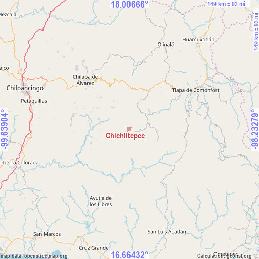
Chichiltepec GPS coordinates[2]
17° 20' 12.192" North, 98° 56' 9.276" West
| Map corner | latitude | longitude |
|---|---|---|
| Upper-left | 18.00666°, | -99.63904° |
| Center: | 17.33672°, | -98.93591° |
| Lower-right: | 16.66432°, | -98.23279° |
| Map W x H: | 149.3×149.3 km | = 92.8×92.8mi |
| max Lat: | 32.7° ⇑84.9% North |
| Chichiltepec: | 17.33672° |
| min Lat: | ⇓15.1% South 14.53588° |
| min Long | Chichiltepec | max Long |
| -117.105° | -98.93591° | -86.73105° |
| W 51.3%⇐ | ⇒48.7% E |
Elevation
Elevation of Chichiltepec is 1554 m = 5098 ft, and this is 300.3 m = 985 ft above average elevation for this country.
| Max E: |
3497 m = 11473 ft | 46.4% |
| Chichiltepec | 1554 m 5098 ft | |
| Avg. | 1253.7 m = 4113 ft | |
Min E: |
-1 m = -3 ft | 53.6% |
See also: Mexico elevation on elevation.city.
Geographical zone
Chichiltepec is located in North Torrid zone (between Equator and Tropic of Cancer). Distance of this Northern Tropic circle is 678.3 km =421.5 mi to North.| Distance of | km | miles | from Chichiltepec |
|---|---|---|---|
| North Pole | 8079.4 | 5020.3 | to North |
| Arctic Circle | 5473.5 | 3401.1 | to North |
| Tropic Cancer | 678.3 | 421.5 | to North |
| Equator | 1927.7 | 1197.8 | to South |


Nearby cities:
15 places around Chichiltepec: (largest is in red/bold)
• Acatepec
3.1 km =1.9 mi,  115°
115°
• Cacahuatepec
7.4 km =4.6 mi,  332°
332°
• Cacalotepec
7.6 km =4.7 mi,  44°
44°
• Caxitepec
5.8 km =3.6 mi,  215°
215°
• Cuixinipa
8.3 km =5.2 mi,  183°
183°
• El Chirimoyo
5 km =3.1 mi,  81°
81°
• Huixolotepec (Huitzolotepec)
4.6 km =2.9 mi, 40°
• Loma Tuza
7.3 km =4.5 mi, 75°
• Mexcalcingo
8.7 km =5.4 mi,  308°
308°
• Popocatzin
10.1 km =6.3 mi,  296°
296°
• San Marcos
7.3 km =4.5 mi,  278°
278°
• Tlalchichiltipán Nuevo
9.6 km =6 mi,  315°
315°
• Tonalapa
3.1 km =1.9 mi,  211°
211°
• Zontecomapa
9.8 km =6.1 mi,  100°
100°
• Zoquitlán
1.5 km =0.9 mi,  292°
292°
Sources, notices
• [Note1] Compared only with cities in Mexico existing in our database
• [Src1] Map data: © OpenStreetMap contributors (CC-BY-SA)
• [Src2] Other city data from geonames.org with taken over terms of usage.
• [Src3] Geographical zone / Annual Mean Temperature by Robert A. Rohde @ Wikipedia
