Acatepec geodata
Acatepec (Guerrero) is a populated place; located in Mexico in America/Mexico_City (GMT-6) time zone. With population of 2,238 people, there are 3926 cities with bigger population in this country. Compared to other cities in Mexico, 85% of cities are located further ↑North; 51.8% of cities are located further ←West and 61.3% of cities have lower elevation than Acatepec. Note1


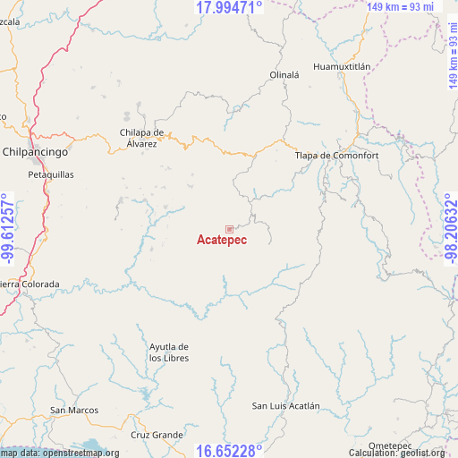
Acatepec GPS coordinates[2]
17° 19' 28.992" North, 98° 54' 33.984" West
| Map corner | latitude | longitude |
|---|---|---|
| Upper-left | 17.99471°, | -99.61257° |
| Center: | 17.32472°, | -98.90944° |
| Lower-right: | 16.65228°, | -98.20632° |
| Map W x H: | 149.3×149.3 km | = 92.8×92.8mi |
| max Lat: | 32.7° ⇑85% North |
| Acatepec: | 17.32472° |
| min Lat: | ⇓15% South 14.53588° |
| min Long | Acatepec | max Long |
| -117.105° | -98.90944° | -86.73105° |
| W 51.8%⇐ | ⇒48.2% E |
Elevation
Elevation of Acatepec is 1748 m = 5735 ft, and this is 494.3 m = 1622 ft above average elevation for this country.
| Max E: |
3497 m = 11473 ft | 38.7% |
| Acatepec | 1748 m 5735 ft | |
| Avg. | 1253.7 m = 4113 ft | |
Min E: |
-1 m = -3 ft | 61.3% |
See also: Mexico elevation on elevation.city.
Geographical zone
Acatepec is located in North Torrid zone (between Equator and Tropic of Cancer). Distance of this Northern Tropic circle is 679.6 km =422.3 mi to North.| Distance of | km | miles | from Acatepec |
|---|---|---|---|
| North Pole | 8080.7 | 5021.1 | to North |
| Arctic Circle | 5474.8 | 3401.9 | to North |
| Tropic Cancer | 679.6 | 422.3 | to North |
| Equator | 1926.3 | 1196.9 | to South |


Nearby cities:
15 places around Acatepec: (largest is in red/bold)
• Apetzuca
8.9 km =5.5 mi,  112°
112°
• Barranca Pobre
8.8 km =5.5 mi,  160°
160°
• Cacahuatepec
10.1 km =6.3 mi,  321°
321°
• Cacalotepec
7.2 km =4.5 mi,  20°
20°
• Caxitepec
7 km =4.3 mi,  241°
241°
• Chichiltepec
3.1 km =1.9 mi,  295°
295°
• Cuixinipa
7.7 km =4.8 mi,  205°
205°
• El Chirimoyo
3 km =1.9 mi,  46°
46°
• Escalerilla Lagunas
8.9 km =5.5 mi, 48°
• Huixolotepec (Huitzolotepec)
4.9 km =3 mi,  2°
2°
• Loma Tuza
5.3 km =3.3 mi, 53°
• San Marcos
10.3 km =6.4 mi,  283°
283°
• Tonalapa
4.6 km =2.9 mi,  253°
253°
• Zontecomapa
6.8 km =4.2 mi,  94°
94°
• Zoquitlán
4.6 km =2.9 mi,  294°
294°
Sources, notices
• [Note1] Compared only with cities in Mexico existing in our database
• [Src1] Map data: © OpenStreetMap contributors (CC-BY-SA)
• [Src2] Other city data from geonames.org with taken over terms of usage.
• [Src3] Geographical zone / Annual Mean Temperature by Robert A. Rohde @ Wikipedia
