Nacatongo geodata
Nacatongo (Morelos) is a populated place; located in Mexico in America/Mexico_City (GMT-6) time zone. With population of 840 people, there are 10414 cities with bigger population in this country. Compared to other cities in Mexico, 66% of cities are located further ↑North; 50.5% of cities are located further ←West and 56.2% of cities have lower elevation than Nacatongo. Note1


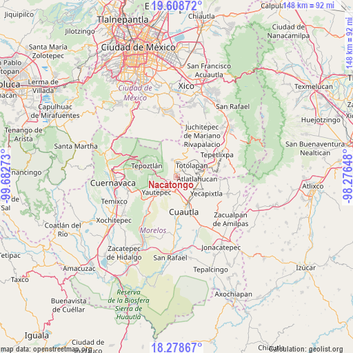
Nacatongo GPS coordinates[2]
18° 56' 42.072" North, 98° 58' 46.56" West
| Map corner | latitude | longitude |
|---|---|---|
| Upper-left | 19.60872°, | -99.68273° |
| Center: | 18.94502°, | -98.9796° |
| Lower-right: | 18.27867°, | -98.27648° |
| Map W x H: | 147.9×147.9 km | = 91.9×91.9mi |
| max Lat: | 32.7° ⇑66% North |
| Nacatongo: | 18.94502° |
| min Lat: | ⇓34% South 14.53588° |
| min Long | Nacatongo | max Long |
| -117.105° | -98.9796° | -86.73105° |
| W 50.5%⇐ | ⇒49.5% E |
Elevation
Elevation of Nacatongo is 1628 m = 5341 ft, and this is 374.3 m = 1228 ft above average elevation for this country.
| Max E: |
3497 m = 11473 ft | 43.8% |
| Nacatongo | 1628 m 5341 ft | |
| Avg. | 1253.7 m = 4113 ft | |
Min E: |
-1 m = -3 ft | 56.2% |
See also: Mexico elevation on elevation.city.
Geographical zone
Nacatongo is located in North Torrid zone (between Equator and Tropic of Cancer). Distance of this Northern Tropic circle is 499.4 km =310.3 mi to North.| Distance of | km | miles | from Nacatongo |
|---|---|---|---|
| North Pole | 7900.6 | 4909.2 | to North |
| Arctic Circle | 5294.7 | 3290 | to North |
| Tropic Cancer | 499.4 | 310.3 | to North |
| Equator | 2106.5 | 1308.9 | to South |


Nearby cities:
15 places around Nacatongo: (largest is in red/bold)
• Amatlipac (San Agustín Amatlipac)
4.5 km =2.8 mi,  13°
13°
• Colonia Puente Pantitlán
2.8 km =1.7 mi,  202°
202°
• Colonia Ángel Bocanegra (Adolfo López Mateos)
5.7 km =3.5 mi,  248°
248°
• Corral Grande
2 km =1.2 mi,  151°
151°
• Cuauhtempan (San Andrés Cuauhtempan)
4.8 km =3 mi,  46°
46°
• El Golán
3.1 km =1.9 mi,  260°
260°
• Emiliano Zapata (Casahuates)
2.7 km =1.7 mi,  126°
126°
• Ignacio Bastida (Santa Catarina Tlayca)
3.7 km =2.3 mi, 261°
• La Cañada (San Sebastián)
5.3 km =3.3 mi, 14°
• Las Vivianas
5.3 km =3.3 mi, 252°
• Lázaro Cárdenas (El Empalme)
5 km =3.1 mi, 253°
• Oacalco
5.8 km =3.6 mi, 245°
• Oaxtepec
3.8 km =2.4 mi,  140°
140°
• San Juan Texcalpan
5.4 km =3.4 mi,  100°
100°
• Tlayacapan
1.2 km =0.7 mi,  352°
352°
Sources, notices
• [Note1] Compared only with cities in Mexico existing in our database
• [Src1] Map data: © OpenStreetMap contributors (CC-BY-SA)
• [Src2] Other city data from geonames.org with taken over terms of usage.
• [Src3] Geographical zone / Annual Mean Temperature by Robert A. Rohde @ Wikipedia
