Miguel Hidalgo geodata
Miguel Hidalgo (Chiapas) is a populated place; located in Mexico in America/Mexico_City (GMT-6) time zone. With population of 678 people, there are 12811 cities with bigger population in this country. Compared to other cities in Mexico, 88.5% of cities are located further ↑North; 95.9% of cities are located further ←West and 64% of cities have higher elevation than Miguel Hidalgo. Note1


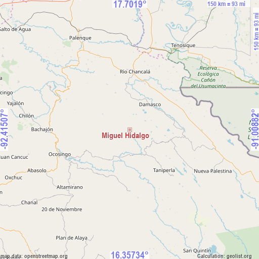
Miguel Hidalgo GPS coordinates[2]
17° 1' 50.988" North, 91° 42' 42.984" West
| Map corner | latitude | longitude |
|---|---|---|
| Upper-left | 17.7019°, | -92.41507° |
| Center: | 17.03083°, | -91.71194° |
| Lower-right: | 16.35734°, | -91.00882° |
| Map W x H: | 149.5×149.5 km | = 92.9×92.9mi |
| max Lat: | 32.7° ⇑88.5% North |
| Miguel Hidalgo: | 17.03083° |
| min Lat: | ⇓11.5% South 14.53588° |
| min Long | Miguel Hidalgo | max Long |
| -117.105° | -91.71194° | -86.73105° |
| W 95.9%⇐ | ⇒4.1% E |
Elevation
Elevation of Miguel Hidalgo is 751 m = 2464 ft, and this is 502.7 m = 1649 ft below average elevation for this country.
| Max E: |
3497 m = 11473 ft | 64% |
| Avg. | 1253.7 m = 4113 ft | |
| Miguel Hidalgo | 751 m = 2464 ft | |
Min E: |
-1 m = -3 ft | 36% |
See also: Mexico elevation on elevation.city.
Geographical zone
Miguel Hidalgo is located in North Torrid zone (between Equator and Tropic of Cancer). Distance of this Northern Tropic circle is 712.3 km =442.6 mi to North.| Distance of | km | miles | from Miguel Hidalgo |
|---|---|---|---|
| North Pole | 8113.4 | 5041.4 | to North |
| Arctic Circle | 5507.5 | 3422.2 | to North |
| Tropic Cancer | 712.3 | 442.6 | to North |
| Equator | 1893.7 | 1176.7 | to South |


Nearby cities:
15 places around Miguel Hidalgo: (largest is in red/bold)
• Ach Lum Monte Líbano
17.2 km =10.7 mi,  148°
148°
• Cinco de Febrero
4.7 km =2.9 mi,  201°
201°
• Damasco
18.7 km =11.6 mi,  39°
39°
• El Diamante
11.4 km =7.1 mi,  354°
354°
• El Tumbo
10.5 km =6.5 mi,  60°
60°
• Jol Sacún
18.2 km =11.3 mi,  300°
300°
• Jol Tulijá
15.7 km =9.8 mi,  0°
0°
• Lacandón
12.5 km =7.8 mi,  94°
94°
• Nueva Esperanza (La Esperanza)
9.7 km =6 mi,  22°
22°
• Pamal Navil
11.2 km =7 mi, 301°
• Peña Limonar
10 km =6.2 mi, 2°
• Plácido Flores
16.8 km =10.4 mi, 150°
• San José Pathuitz
18.3 km =11.4 mi, 17°
• San Luis (Guadalupe)
13.7 km =8.5 mi,  140°
140°
• Zaragoza
8 km =5 mi,  107°
107°
Sources, notices
• [Note1] Compared only with cities in Mexico existing in our database
• [Src1] Map data: © OpenStreetMap contributors (CC-BY-SA)
• [Src2] Other city data from geonames.org with taken over terms of usage.
• [Src3] Geographical zone / Annual Mean Temperature by Robert A. Rohde @ Wikipedia
