Pamal Navil geodata
Pamal Navil (Chiapas) is a populated place; located in Mexico in America/Mexico_City (GMT-6) time zone. With population of 588 people, there are 14598 cities with bigger population in this country. Compared to other cities in Mexico, 87.8% of cities are located further ↑North; 95.8% of cities are located further ←West and 59.5% of cities have higher elevation than Pamal Navil. Note1


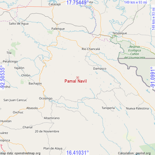
Pamal Navil GPS coordinates[2]
17° 5' 0.996" North, 91° 48' 7.992" West
| Map corner | latitude | longitude |
|---|---|---|
| Upper-left | 17.75449°, | -92.50535° |
| Center: | 17.08361°, | -91.80222° |
| Lower-right: | 16.41031°, | -91.0991° |
| Map W x H: | 149.5×149.5 km | = 92.9×92.9mi |
| max Lat: | 32.7° ⇑87.8% North |
| Pamal Navil: | 17.08361° |
| min Lat: | ⇓12.2% South 14.53588° |
| min Long | Pamal Navil | max Long |
| -117.105° | -91.80222° | -86.73105° |
| W 95.8%⇐ | ⇒4.2% E |
Elevation
Elevation of Pamal Navil is 1028 m = 3373 ft, and this is 225.7 m = 740 ft below average elevation for this country.
| Max E: |
3497 m = 11473 ft | 59.5% |
| Avg. | 1253.7 m = 4113 ft | |
| Pamal Navil | 1028 m = 3373 ft | |
Min E: |
-1 m = -3 ft | 40.5% |
See also: Mexico elevation on elevation.city.
Geographical zone
Pamal Navil is located in North Torrid zone (between Equator and Tropic of Cancer). Distance of this Northern Tropic circle is 706.4 km =438.9 mi to North.| Distance of | km | miles | from Pamal Navil |
|---|---|---|---|
| North Pole | 8107.5 | 5037.8 | to North |
| Arctic Circle | 5501.7 | 3418.6 | to North |
| Tropic Cancer | 706.4 | 438.9 | to North |
| Equator | 1899.5 | 1180.3 | to South |


Nearby cities:
15 places around Pamal Navil: (largest is in red/bold)
• Cinco de Febrero
12.9 km =8 mi,  142°
142°
• El Diamante
10 km =6.2 mi,  57°
57°
• El Tumbo
18.7 km =11.6 mi,  91°
91°
• Jet-Já
13.5 km =8.4 mi,  262°
262°
• Jol Sacún
6.9 km =4.3 mi,  299°
299°
• Jol Tulijá
13.9 km =8.6 mi,  44°
44°
• La Reforma
17.5 km =10.9 mi,  216°
216°
• Miguel Hidalgo
11.2 km =7 mi,  121°
121°
• Nazaret
16.6 km =10.3 mi,  225°
225°
• Nueva Esperanza (La Esperanza)
13.7 km =8.5 mi,  76°
76°
• Peña Limonar
10.9 km =6.8 mi,  67°
67°
• Sacún Cubwitz
15.6 km =9.7 mi,  288°
288°
• San Jerónimo Tulijá
15.6 km =9.7 mi,  4°
4°
• San José Pathuitz
18.9 km =11.7 mi,  52°
52°
• San Salvador
14.8 km =9.2 mi,  212°
212°
Sources, notices
• [Note1] Compared only with cities in Mexico existing in our database
• [Src1] Map data: © OpenStreetMap contributors (CC-BY-SA)
• [Src2] Other city data from geonames.org with taken over terms of usage.
• [Src3] Geographical zone / Annual Mean Temperature by Robert A. Rohde @ Wikipedia
