Lacandón geodata
Lacandón (Chiapas) is a populated place; located in Mexico in America/Mexico_City (GMT-6) time zone. With population of 1,062 people, there are 8219 cities with bigger population in this country. Compared to other cities in Mexico, 88.6% of cities are located further ↑North; 96.2% of cities are located further ←West and 63.2% of cities have higher elevation than Lacandón. Note1


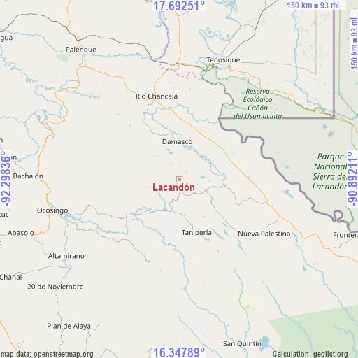
Lacandón GPS coordinates[2]
17° 1' 17.076" North, 91° 35' 42.828" West
| Map corner | latitude | longitude |
|---|---|---|
| Upper-left | 17.69251°, | -92.29836° |
| Center: | 17.02141°, | -91.59523° |
| Lower-right: | 16.34789°, | -90.89211° |
| Map W x H: | 149.5×149.5 km | = 92.9×92.9mi |
| max Lat: | 32.7° ⇑88.6% North |
| Lacandón: | 17.02141° |
| min Lat: | ⇓11.4% South 14.53588° |
| min Long | Lacandón | max Long |
| -117.105° | -91.59523° | -86.73105° |
| W 96.2%⇐ | ⇒3.8% E |
Elevation
Elevation of Lacandón is 803 m = 2635 ft, and this is 450.7 m = 1479 ft below average elevation for this country.
| Max E: |
3497 m = 11473 ft | 63.2% |
| Avg. | 1253.7 m = 4113 ft | |
| Lacandón | 803 m = 2635 ft | |
Min E: |
-1 m = -3 ft | 36.8% |
See also: Mexico elevation on elevation.city.
Geographical zone
Lacandón is located in North Torrid zone (between Equator and Tropic of Cancer). Distance of this Northern Tropic circle is 713.3 km =443.2 mi to North.| Distance of | km | miles | from Lacandón |
|---|---|---|---|
| North Pole | 8114.5 | 5042.1 | to North |
| Arctic Circle | 5508.6 | 3422.9 | to North |
| Tropic Cancer | 713.3 | 443.2 | to North |
| Equator | 1892.6 | 1176 | to South |


Nearby cities:
15 places around Lacandón: (largest is in red/bold)
• Ach Lum Monte Líbano
14 km =8.7 mi,  194°
194°
• Cinco de Febrero
14.5 km =9 mi,  256°
256°
• El Jardín
8.9 km =5.5 mi,  129°
129°
• El Sibal
12 km =7.5 mi,  112°
112°
• El Tumbo
7.1 km =4.4 mi,  332°
332°
• La Arena
13 km =8.1 mi,  36°
36°
• Miguel Hidalgo
12.5 km =7.8 mi,  274°
274°
• Nueva Esperanza (La Esperanza)
13.2 km =8.2 mi,  319°
319°
• Nuevo Jericó
13.5 km =8.4 mi,  24°
24°
• Ojo de Agua
12.7 km =7.9 mi,  69°
69°
• Plácido Flores
14.2 km =8.8 mi,  197°
197°
• San Luis (Guadalupe)
10.3 km =6.4 mi, 201°
• Santa Elena
14.3 km =8.9 mi,  177°
177°
• Ubilio García
14.8 km =9.2 mi,  61°
61°
• Zaragoza
5 km =3.1 mi,  254°
254°
Sources, notices
• [Note1] Compared only with cities in Mexico existing in our database
• [Src1] Map data: © OpenStreetMap contributors (CC-BY-SA)
• [Src2] Other city data from geonames.org with taken over terms of usage.
• [Src3] Geographical zone / Annual Mean Temperature by Robert A. Rohde @ Wikipedia
