Loma Linda geodata
Loma Linda (State of Mexico) is a populated place; located in Mexico in America/Mexico_City (GMT-6) time zone. With population of 518 people, there are 16254 cities with bigger population in this country. Compared to other cities in Mexico, 57.2% of cities are located further ↓South; 61.7% of cities are located further →East and 97.7% of cities have lower elevation than Loma Linda. Note1


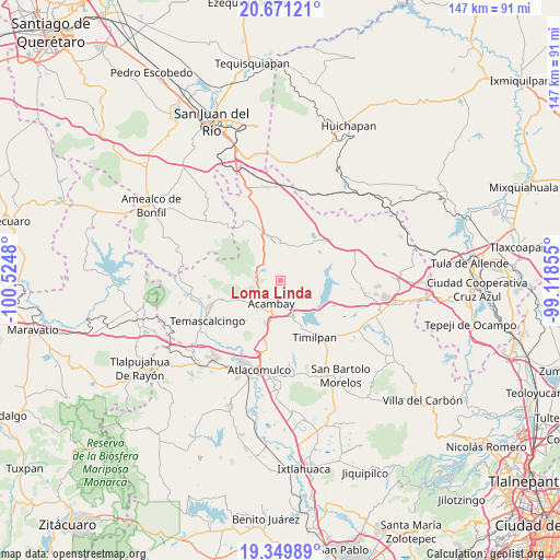
Loma Linda GPS coordinates[2]
20° 0' 42.984" North, 99° 49' 18.012" West
| Map corner | latitude | longitude |
|---|---|---|
| Upper-left | 20.67121°, | -100.5248° |
| Center: | 20.01194°, | -99.82167° |
| Lower-right: | 19.34989°, | -99.11855° |
| Map W x H: | 146.9×146.9 km | = 91.3×91.3mi |
| max Lat: | 32.7° ⇑42.8% North |
| Loma Linda: | 20.01194° |
| min Lat: | ⇓57.2% South 14.53588° |
| min Long | Loma Linda | max Long |
| -117.105° | -99.82167° | -86.73105° |
| W 38.3%⇐ | ⇒61.7% E |
Elevation
Elevation of Loma Linda is 2726 m = 8944 ft, and this is 1472.3 m = 4830 ft above average elevation for this country.
| Max E: |
3497 m = 11473 ft | 2.3% |
| Loma Linda | 2726 m 8944 ft | |
| Avg. | 1253.7 m = 4113 ft | |
Min E: |
-1 m = -3 ft | 97.7% |
See also: Mexico elevation on elevation.city.
Geographical zone
Loma Linda is located in North Torrid zone (between Equator and Tropic of Cancer). Distance of this Northern Tropic circle is 380.8 km =236.6 mi to North.| Distance of | km | miles | from Loma Linda |
|---|---|---|---|
| North Pole | 7781.9 | 4835.4 | to North |
| Arctic Circle | 5176.1 | 3216.3 | to North |
| Tropic Cancer | 380.8 | 236.6 | to North |
| Equator | 2225.1 | 1382.6 | to South |


Nearby cities:
15 places around Loma Linda: (largest is in red/bold)
• Acambay
6.7 km =4.2 mi,  200°
200°
• Botidi
5.5 km =3.4 mi, 203°
• Buenavista
2.5 km =1.6 mi,  99°
99°
• Detiña (San Antonio Detiña)
8 km =5 mi,  234°
234°
• Endeje
5.9 km =3.7 mi, 195°
• Fondo
7.9 km =4.9 mi,  47°
47°
• Ganzda
3.6 km =2.2 mi, 227°
• La Caridad
7.3 km =4.5 mi,  192°
192°
• La Palma
9.3 km =5.8 mi,  269°
269°
• La Soledad Barrio
8.9 km =5.5 mi,  359°
359°
• La Soledad Ejido
9 km =5.6 mi,  337°
337°
• San Ildefonso (San Ildefonso Yolotepec)
8.5 km =5.3 mi, 191°
• San Juanico Sector Dos
9 km =5.6 mi,  154°
154°
• Santa María Nativitas
9.2 km =5.7 mi,  15°
15°
• Ñado Buenavista
6.6 km =4.1 mi,  323°
323°
Sources, notices
• [Note1] Compared only with cities in Mexico existing in our database
• [Src1] Map data: © OpenStreetMap contributors (CC-BY-SA)
• [Src2] Other city data from geonames.org with taken over terms of usage.
• [Src3] Geographical zone / Annual Mean Temperature by Robert A. Rohde @ Wikipedia
