Acatlán geodata
Acatlán (Veracruz) is a seat of a second-order administrative division; located in Mexico in America/Mexico_City (GMT-6) time zone. With population of 2,929 people, there are 3043 cities with bigger population in this country. Compared to other cities in Mexico, 50.3% of cities are located further ↓South; 76.8% of cities are located further ←West and 61.4% of cities have lower elevation than Acatlán. Note1


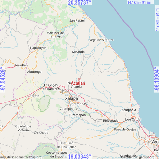
Acatlán GPS coordinates[2]
19° 41' 48.372" North, 96° 50' 31.776" West
| Map corner | latitude | longitude |
|---|---|---|
| Upper-left | 20.35737°, | -97.54529° |
| Center: | 19.69677°, | -96.84216° |
| Lower-right: | 19.03343°, | -96.13904° |
| Map W x H: | 147.2×147.2 km | = 91.5×91.5mi |
| max Lat: | 32.7° ⇑49.7% North |
| Acatlán: | 19.69677° |
| min Lat: | ⇓50.3% South 14.53588° |
| min Long | Acatlán | max Long |
| -117.105° | -96.84216° | -86.73105° |
| W 76.8%⇐ | ⇒23.2% E |
Elevation
Elevation of Acatlán is 1749 m = 5738 ft, and this is 495.3 m = 1625 ft above average elevation for this country.
| Max E: |
3497 m = 11473 ft | 38.6% |
| Acatlán | 1749 m 5738 ft | |
| Avg. | 1253.7 m = 4113 ft | |
Min E: |
-1 m = -3 ft | 61.4% |
See also: Mexico elevation on elevation.city.
Geographical zone
Acatlán is located in North Torrid zone (between Equator and Tropic of Cancer). Distance of this Northern Tropic circle is 415.8 km =258.4 mi to North.| Distance of | km | miles | from Acatlán |
|---|---|---|---|
| North Pole | 7817 | 4857.3 | to North |
| Arctic Circle | 5211.1 | 3238 | to North |
| Tropic Cancer | 415.8 | 258.4 | to North |
| Equator | 2190.1 | 1360.9 | to South |


Nearby cities:
15 places around Acatlán: (largest is in red/bold)
• Chiconquiaco
5.6 km =3.5 mi,  26°
26°
• El Espinal
8.6 km =5.3 mi,  201°
201°
• Landero y Coss
4.4 km =2.7 mi,  345°
345°
• Las Haldas
7.8 km =4.8 mi,  166°
166°
• Los Planes (Cerro Gordo)
9.6 km =6 mi,  247°
247°
• Mafafas
10 km =6.2 mi,  115°
115°
• Miahuatlán
3.2 km =2 mi,  292°
292°
• Naolinco de Victoria
5.7 km =3.5 mi,  214°
214°
• Piedras Grandes
7.8 km =4.8 mi,  273°
273°
• Puentezuelos
9.1 km =5.7 mi,  281°
281°
• San Marcos Atesquilapan
4.6 km =2.9 mi,  260°
260°
• Tenampa
9.7 km =6 mi,  192°
192°
• Tepetlán
5.4 km =3.4 mi, 119°
• Tonayán
8.4 km =5.2 mi, 259°
• Vicente Guerrero (Tepetates)
10.3 km =6.4 mi,  159°
159°
Sources, notices
• [Note1] Compared only with cities in Mexico existing in our database
• [Src1] Map data: © OpenStreetMap contributors (CC-BY-SA)
• [Src2] Other city data from geonames.org with taken over terms of usage.
• [Src3] Geographical zone / Annual Mean Temperature by Robert A. Rohde @ Wikipedia
