Tenochtitlán geodata
Tenochtitlán (Veracruz) is a populated place; located in Mexico in America/Mexico_City (GMT-6) time zone. With population of 1,911 people, there are 4550 cities with bigger population in this country. Compared to other cities in Mexico, 53% of cities are located further ↓South; 75.9% of cities are located further ←West and 61.6% of cities have higher elevation than Tenochtitlán. Note1


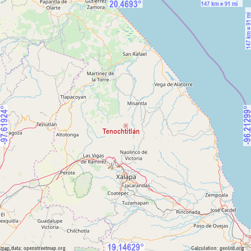
Tenochtitlán GPS coordinates[2]
19° 48' 33.012" North, 96° 54' 57.996" West
| Map corner | latitude | longitude |
|---|---|---|
| Upper-left | 20.4693°, | -97.61924° |
| Center: | 19.80917°, | -96.91611° |
| Lower-right: | 19.14629°, | -96.21299° |
| Map W x H: | 147.1×147.1 km | = 91.4×91.4mi |
| max Lat: | 32.7° ⇑47% North |
| Tenochtitlán: | 19.80917° |
| min Lat: | ⇓53% South 14.53588° |
| min Long | Tenochtitlán | max Long |
| -117.105° | -96.91611° | -86.73105° |
| W 75.9%⇐ | ⇒24.1% E |
Elevation
Elevation of Tenochtitlán is 902 m = 2959 ft, and this is 351.7 m = 1154 ft below average elevation for this country.
| Max E: |
3497 m = 11473 ft | 61.6% |
| Avg. | 1253.7 m = 4113 ft | |
| Tenochtitlán | 902 m = 2959 ft | |
Min E: |
-1 m = -3 ft | 38.4% |
See also: Mexico elevation on elevation.city.
Geographical zone
Tenochtitlán is located in North Torrid zone (between Equator and Tropic of Cancer). Distance of this Northern Tropic circle is 403.3 km =250.6 mi to North.| Distance of | km | miles | from Tenochtitlán |
|---|---|---|---|
| North Pole | 7804.5 | 4849.5 | to North |
| Arctic Circle | 5198.6 | 3230.3 | to North |
| Tropic Cancer | 403.3 | 250.6 | to North |
| Equator | 2202.6 | 1368.6 | to South |


Nearby cities:
15 places around Tenochtitlán: (largest is in red/bold)
• Chiconquiaco
12.6 km =7.8 mi,  126°
126°
• Landero y Coss
10.6 km =6.6 mi,  141°
141°
• Las Paredes
8.3 km =5.2 mi,  102°
102°
• Leona Vicario
13.1 km =8.1 mi,  67°
67°
• Manuel Gutiérrez Nájera
6 km =3.7 mi,  107°
107°
• Miahuatlán
12.2 km =7.6 mi,  157°
157°
• Paso Blanco
7.9 km =4.9 mi,  34°
34°
• Piedras Grandes
12.1 km =7.5 mi,  180°
180°
• Pueblo Viejo
4.5 km =2.8 mi,  80°
80°
• Puentezuelos
10.7 km =6.6 mi,  186°
186°
• Quilate Nuevo
10.1 km =6.3 mi,  315°
315°
• Salvador Díaz Mirón
5.2 km =3.2 mi,  120°
120°
• San Marcos Atesquilapan
13.7 km =8.5 mi,  166°
166°
• Tonayán
14 km =8.7 mi, 182°
• Vicente Guerrero
6.2 km =3.9 mi,  12°
12°
Sources, notices
• [Note1] Compared only with cities in Mexico existing in our database
• [Src1] Map data: © OpenStreetMap contributors (CC-BY-SA)
• [Src2] Other city data from geonames.org with taken over terms of usage.
• [Src3] Geographical zone / Annual Mean Temperature by Robert A. Rohde @ Wikipedia
